
Weather Watch with Rick Gordon
Click below for Rick’s exclusive videocast
Friday’s Weather
Some sunshine, extremely warm, and humid with a high of 89 degrees, feeling like 96.
5-Day Forecast July 5-July 9
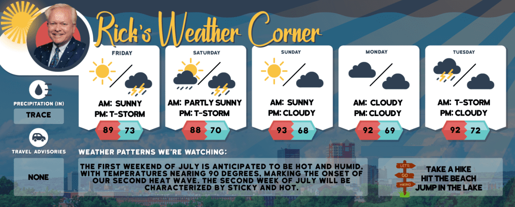
Today: Some sun, very warm, and muggy. High 89 (feel like 96) Winds: S 5-10 mph
Tonight: Some clouds, very warm, & muggy with a late-night thunderstorm. Low 73 Winds: SSE 5-10 mph
Saturday: Expect some sunshine, very warm temperatures, and muggy conditions, with potential afternoon thunderstorms. Be cautious of flash flooding, hail, and localized damaging wind gusts. High 88 (feel like 96) Winds: SSW 10-15 mph
Saturday night: Expect scattered thunderstorms in the evening, followed by partly cloudy skies & muggy conditions overnight. Low 70 Winds: S 5-10 mph
Sunday (Start of our 2nd heat wave.): Hazy sun, hot, and not as muggy; but still humid. High 93 (feel like 97) Winds: SSW 5-10 mph
Sunday night: Some clouds & humid. Low 68 Winds: Light & Variable
Monday: Hot with hazy sun & humid. High 92 (feel like 98) Winds: SSE 5-10 mph
Monday night: Some clouds & humid. Low 69 Winds SSE 5-10 mph
Tuesday: Mostly cloudy with heat; expect sporadic morning rain and a thunderstorm, then isolated thunderstorms in the afternoon. High 92 (feel like 94) Winds: SSW 5-10 mph
Tuesday night: Cloudy, warm, and humid. Low 72 Winds: S 5-10 mph
Weather Patterns We’re Watching
The first weekend of July is anticipated to be hot and humid, with temperatures nearing 90 degrees, marking the onset of our second heat wave. The second week of July will be characterized by sticky and hot.
Hiking/Beach/Lake Forecasts
Take a Hike
Elevations for summits above 4,000 feet in Northern New Hampshire Today: Summits will be obscured with a possibility of showers. Expect highs in the upper 60s. Westerly winds will be around 10 mph in the morning, then becoming light and variable. There’s a 40 percent chance of rain.
Elevations between 2,500 and 4,000 feet in Northern New Hampshire Today: Summits will be obscured. There’s a possibility of showers with highs in the upper 60s. Westerly winds will be around 10 mph in the morning, then becoming light and variable. There’s a 40 percent chance of rain.
Hit the Beach
- Weather: Partly sunny.
- UV Index: Very high.
- Thunderstorm Potential: None.
- High Temperature: In the mid-70s.
- Winds: South winds around 5 mph.
- Water Temperature: 60 degrees.
- Surf Height: Around 2 feet.
- Rip Tide Current Risk: Low.
- Tides Hampton Beach: High 8.1 feet (MLLW) 11:46 AM. Low 0.8 feet (MLLW) 05:52 PM.
Jump in a Lake
Winds will be light and variable, shifting to the southeast at approximately 5 mph in the afternoon. Expect waves to be around one foot. The day will be partly sunny, with a slight chance of showers and thunderstorms later in the afternoon. It will be humid, with high temperatures in the lower 80s. The probability of rain is 20 percent. The threat of lightning is considered low, indicating a minimal chance of thunderstorms. The water temperature will be 73 degrees Fahrenheit.