
The Windy.com interactive graphic above allows you to zoom in and out, fast-forward to see the futurecast, and check on various weather patterns here in NH and around the country. Select from menu in the top right corner.
Monday’s Weather
Weather Alert

5-Day Outlook Aug. 23 – Aug. 27
Today: Some wind, periods of rain & an afternoon thunderstorm (.50″) from Tropical Rainstorm Henri High 81 Winds: ESE 10-15 with gusts 25 mph
Tonight: Some rain (.50″) from Tropical rainstorm Henri Low 70 Winds: ENE 5-15 mph
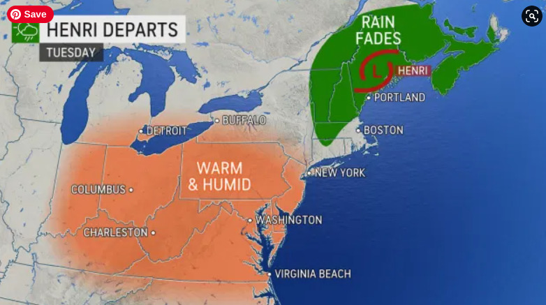
Tuesday: Mix sun & clouds; warmer & humid with a spot thunderstorm High 89 (feel like 94) Winds: WNW 5-10 mph
Tuesday night: Clear, warm & humid Low 69 Winds: WNW 5-10 mph
Wednesday: Mostly sunny, hot & humid High 90 (feel like 96) Winds: Light & Variable
Wednesday Night: Clear, warm & humid Low 71 Winds: Light & Variable
Thursday: Some sun, hot & humid with a spot thunderstorm High 92 (fell like 96) Winds: SW 5-10 mph
Thursday night: Mainly clear, warm and humid Low 70 Winds: WNW5-10 mph
Friday: Mix sun & clouds; not as hot and turning less humid High 83 Winds: NNW 5-10 mph
Friday night: Partly cloudy and comfortable Low 59 Winds: NNE 5-10 mph
Weather Patterns We’re Watching
A summery pattern with highs into the 90s for Wednesday & Thursday with a few bouts of spot showers and thunderstorms.

Beach Forecast for Hampton & Rye
Be an official Ink Link Weather Spotter!
Rick Gordon could use your help. If you are interested in becoming a local weather spotter (all locations around NH) contact Rick at gordonwx@comcast.net and he’ll walk you through the process!
