
Friday’s Weather
Ice storm this morning with a quarter to a half-inch of freezing rain accumulation for southern New Hampshire. Heavy sleet with an inch to an inch and a half on top of the freezing rain before it changes to snow by late morning. This leads to an extremely difficult commute this morning with icy conditions. This mess transitions to all snow (3-5″ of sleet & snow) over southern New Hampshire during the day.
WINTER STORM WARNING IS IN EFFECT UNTIL 7 PM TONIGHT.
WHAT: Heavy mixed precipitation is expected. Total snow accumulations of 6 to 10 inches across south-central New Hampshire to 3 to 7 inches over southern areas, sleet accumulations of around an inch to an inch and a half, and ice accumulations of around two-tenths of an inch expected.
WHERE: Portions of central and southern New Hampshire.
WHEN: Until 7 PM tonight.
IMPACTS: Travel could be very difficult to impossible. The hazardous conditions will impact the morning commute. PRECAUTIONARY/PREPAREDNESS ACTIONS: If you must travel, keep an extra flashlight, food, and water in your vehicle in case of an emergency.
Total snowfall today.

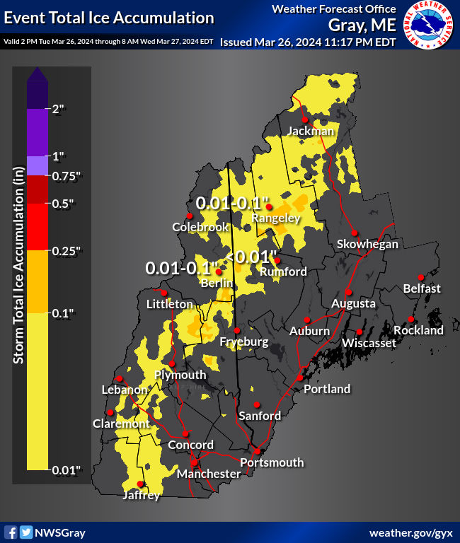
Total ice accumulation.
 5-Day Outlook Feb. 4- Feb. 8
Today: Cloudy & colder with ice changing to snow (3-5″ of sleet and snow) High Falling into the 20s Winds: NNE 10-15 mph
Tonight: Snow showers early followed by partial clearing. Low 14 Winds: NNW5-10 mph
Saturday: Mix sun & clouds. High 23 (feel like 10) Winds: NW 10-15 mph
Saturday night: Clear and fridge. Low -6 Winds: Light & Variable
Sunday: Clouding up. High 29 Winds: SSW 5-10 mph
Sunday night: Mostly cloudy. Low 20 Winds: Light & Variable
Monday: Mostly cloudy and not as cold. High 37 Winds: Light & Variable
Monday night: Mostly cloudy with snow showers (Trace-1″). Low 25 Winds: Light & Variable
Tuesday: Mostly cloudy with some snow showers. High 37 Winds: NNW 5-10 mph
Tuesday night: Partly cloudy and cold. Low 19 Winds: NW 5-10 mph
Be an official Ink Link Weather Spotter!
Rick Gordon could use your help. If you are interested in becoming a local weather spotter (all locations around NH) contact Rick at gordonwx@comcast.net and he’ll walk you through the process!

Weather Patterns We’re Watching
A dry and very cold weekend with milder air next week.
Ski Report via Ski NH

Summits above 4,000 feet in Northern New Hampshire Today:
Summits obscured. Snow (12-16″). Highs 11 to 21. Northeast winds 25 to 35 mph with gusts up to 45 mph. Chance of snow 90 percent. Wind chill values as low as 16 below.
Elevations between 2,500 and 4,000 feet in Northern New Hampshire Today:
Cloudy, snow (12-16″). Highs 11 to 21. Northeast winds 15 to 25 mph. Chance of snow 90 percent. Wind chill values as low as 19 below.
Click below for ski conditions at your favorite resorts: