
BELOW: Today’s Weather Watch with Rick Gordon

Friday’s Weather
As the ridge builds into New England today, the airmass continues to warm up. This yields a mostly sunny day with temperatures warming into the upper 70s to near 80. A light sea breeze develops in the afternoon along the coastline, causing temps to drop by a few degrees.
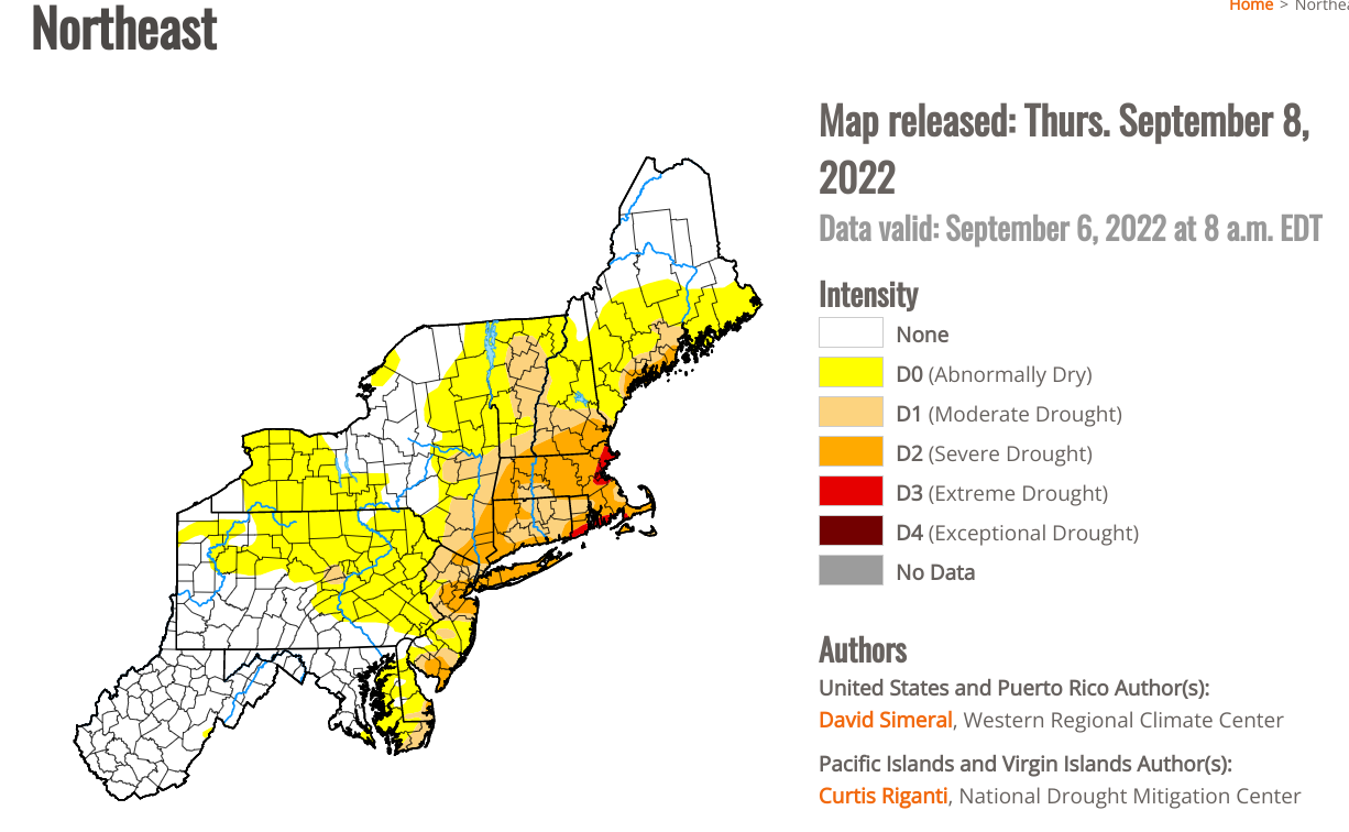
Drought Update for September
We are still in a severe drought even with 2″ of rain earlier this week. We are still close to 3″ below normal in rainfall.
Click here to view an interactive version of the below.
5-Day Outlook Sept. 8-Sept. 11
Weather Patterns We’re Watching
The Great Outdoors Weather Report

Summits above 4,000 feet in Northern New Hampshire Today:
Mostly sunny in the morning, then summits in and out of clouds. Highs in the mid-60s… except around 60 at elevations above 5,000 feet. North winds 10 to 20 mph.
Elevations between 2,500 and 4,000 feet in Northern New Hampshire Today:
Partly sunny in the morning, then summits in and out of clouds. Highs in the lower 70s. North winds up to 10 mph.

Photo/Jeffrey Hastings
Beach Forecast
An easterly swell will begin to build this afternoon along the coastline, generated by the interaction between Hurricane Earl south of Bermuda and High pressure across Atlantic Canada. Although waves will only be around 3 feet by late in the day, the long period of the swell will cause rip currents to strengthen by the weekend.
Weather: Pleasant with plenty of sunshine.
U.V. Index: Moderate.
Thunderstorm Potential: None.
High Temperature: In the lower 70s.
Wind: North winds around 5 mph, becoming southeast in the afternoon.
Surf height: Around 3 feet.
Rip Current Risk: Low.
Water temperature: 64 degrees.
Tides for Hampton Beach: High 8.9 feet (MLLW) 11:02 AM. Low -0.2 feet (MLLW) 05:19 PM.

Lake Forecast for Lake Winnipesaukee