
Weather Watch Video
/p>
Monday’s Weather
Our weather pattern today remains unsettled which will last through the week, with daily opportunities for isolated to scattered rain showers. Temperatures will be below normal. Yesterday 1.92″ of rain was record-breaking, the old record of 1.09″ set in 2012.

The latest 8–14-day (April 30-May 6) temperature and precipitation outlooks favor below-average temperatures and above-average precipitation across New Hampshire. 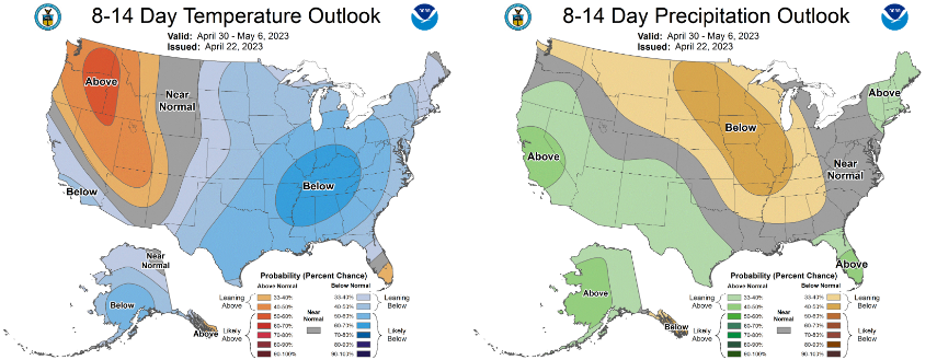
Five-Day Forecast
Today: Cloudy & cool with some spotty showers. High 53 Winds: NE 5-10 mph
Tonight: Mostly cloudy with a few early showers. Low 42 Winds: NW 5-10 mph
Tuesday: Milder with sunny breaks along with a spot shower. High 56 Winds: NW 5-10 mph
Tuesday night: Some clearing late. Low 39 Winds: NW 5-10 mph
Wednesday: Mix sun & clouds. High 60 Winds: W 5-10 mph
Wednesday night: Partly cloudy to mostly cloudy with showers late. Low 40 Winds: Light & Variable
Thursday: Mostly cloudy with a few showers. High 57 Winds: NE 5-10 mph
Thursday night: Early showers then cloudy. Low 43 Winds: NE 5-10 mph
Friday: Some sun with a few showers. High 58 Winds: ENE 5-10
Friday night: Partly cloudy. Low 41 Winds: NNW 5-10 mph
Weather Patterns We’re Watching
 Hiking Report
White Mountains Weather
The forecast for summits above 4,000 feet in Northern New Hampshire: Summits obscured. Rain is likely in the morning. Snow showers are likely. Rain showers are likely in the afternoon. Highs in the mid-30s. Southeast winds 15 to 25 mph. Chance of precipitation 70 percent. Wind chill values are as low as 17.
The forecast for elevations between 2,500 and 4,000 feet in Northern New Hampshire: Summits obscured. Rain is likely in the morning, then rain showers are likely in the afternoon. Highs in the upper 30s. Southeast winds 10 to 15 mph with gusts up to 25 mph. Chance of rain 70 percent.