
Weather Watch with Rick Gordon
Below: Watch your weather outlook via YouTube, delivered in two minutes.
Friday’s Weather
Today is cloudy and humid with a heavy thunderstorm with the potential to bring flash flooding and damaging winds. High today 82 but feeling like 90.
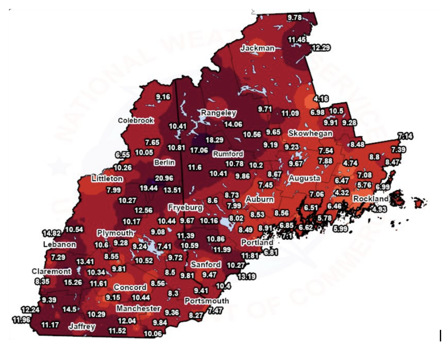
Here Comes the Rain Again
Wondering how much rain we’ve had in the past month and a half? Take a look. Many locations across the region have had over 15 inches of rain since June 1st. That’s more than doubled how much rainfall usually falls within this time period. Here in Manchester so far 9.38″. It has been one wet summer for sure.
Flash Flooding
5-Day Forecast July 14 – 18

Weather Patterns We’re Watching
Next week looking mainly dry with temperatures in the mid-upper 80s.
 Hiking Report/White Mountains Weather
Elevations for summits above 4,000 feet in Northern New Hampshire Today: Cloudy. Showers with a chance of thunderstorms. Some thunderstorms may produce heavy rainfall. Highs in the upper 60s. Southwest winds 15 to 25 mph. Chance of rain 80 percent.
Elevations between 2,500 and 4,000 feet in Northern New Hampshire Today: Summits in and out of clouds. A chance of showers in the morning. A chance of thunderstorms. Showers are likely in the afternoon. Some thunderstorms may produce heavy rainfall. Highs in the lower 70s. South winds 10 to 15 mph with gusts up to 25 mph. Chance of rain 70 percent.

BEACH FORECAST
Weather: Variable clouds with a couple of showers and a heavy thunderstorm; humid; storms can bring flash flooding and damaging winds
UV Index: Moderate.
Thunderstorm Potential: Moderate. Implies that thunderstorms are possible.
High Temperature: In the middle 70s.
Winds: South winds 5 to 10 mph.
Surf Height: 2 to 3 feet.
Water Temperature: 70 degrees.
Rip Current Risk: Low.
Tides Hampton Beach: High 7.7 feet (MLLW) 09:50 AM. Low 1.2 feet (MLLW) 04:00 PM.
 View on Lake Winnipiseogee (1828) by American painter Thomas Cole