Weather Watch with Rick Gordon
Below: Watch your weather outlook via YouTube, delivered in two minutes.
Saturday’s Weather
Today warm and humid conditions will last through the weekend as a slow-moving front approaches from the west. There will be rounds of showers and thunderstorms through the weekend with most of the time being dry.

5-Day Outlook, Sept. 9–13
Today: Some hazy sun & humid with spot thunderstorms. High 85 (feel like 90) Winds: SW 5-10 mph
Tonight: Mostly cloudy, warm, and humid with a few thunderstorms. Low 70 Winds: Light & Variable
Sunday: Cloudy & humid with some showers and thunderstorms. High Around 80 Winds: Light & Variable
Sunday night: Humid & warm with some evening showers & thunderstorms. Low 68 Winds: Light & Variable
Monday: Humid with some showers & thunderstorms. High 77 Winds: Light & Variable
Monday night: Lots of clouds & humid. Low 64 Winds: Light & Variable
Tuesday: Some clouds with a few showers & not as humid. High 76 Winds: NNE 5-10 mph
Tuesday night: Some showers. Low 63 Winds: Light& Variable
Wednesday: Cloudy with some afternoon showers. High 74 Winds: ESE 5-10 mph
Wednesday night: Some evening showers & thunderstorms. Low 64 Winds: ESE 5-10 mph
Risk Trend for Hurricane Lee
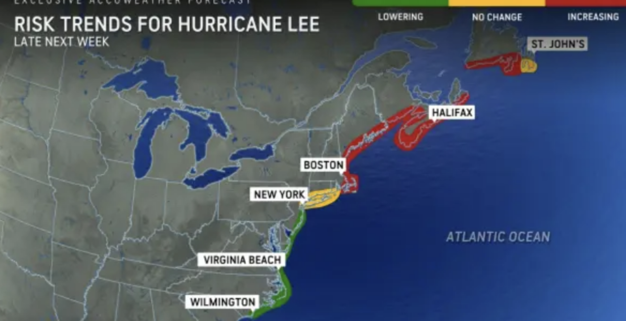
The risk of direct impacts is increasing from New England to the Canadian Maritime Provinces and the large Canadian island of Newfoundland. Late next week into next weekend Lee will either make landfall somewhere from New England to Atlantic Canada or perhaps stay out to sea with a sweep to the east of Newfoundland.
Weather Patterns We’re Watching
Hurricane Lee’s direct impacts are increasing from New England to the Canadian Maritime Provinces and the large Canadian island of Newfoundland late next week into next weekend.
 Hiking Report/White Mountains Weather
Elevations for summits above 4,000 feet in Northern New Hampshire Today: Summits in and out of clouds. A chance of showers in the morning. Showers are likely in the afternoon. Highs in the mid-60s. West winds around 30 mph with gusts up to 40 mph decreasing to around 20 mph in the afternoon. Chance of rain 60 percent
Elevations between 2,500 and 4,000 feet in Northern New Hampshire Today: Cloudy. A chance of showers. Highs in the upper 60s. West winds 10 to 15 mph. Gusts up to 30 mph in the morning. Chance of rain 50 percent.
BEACH FORECAST
Weather: Partly sunny. Patchy fog. A chance of showers and a slight chance of thunderstorms.
UV Index: Low.
Thunderstorm Potential: Low. Implies that there is little chance of thunderstorms.
High Temperature: In the upper 70s.
Winds: South winds 5 to 10 mph.
Surf Height: Around 2 feet.
Water Temperature: 67 degrees.
Rip Current Risk: Low.
Tides Hampton Beach: High 7.3 feet (MLLW) 08:07 AM. Low 1.7 feet (MLLW) 02:20 P
 View on Lake Winnipiseogee (1828) by American painter Thomas Cole
Lake Forecast
Southwest winds around 5 mph. Waves around 1 foot. Partly sunny with a slight chance of thunderstorms. A chance of showers in the morning then showers likely in the afternoon. Humid with highs in the upper 70s. Chance of rain 60 percent. The lightning threat is low, which implies that there is little chance of thunderstorms. The water temperature is 76 degrees.

