
Rick Gordon’s Weather Watch
Follow our YouTube channel here.
Today’s Weather
Hot and muggy with sun and clouds; a few showers and a severe thunderstorm in the afternoon. Thunderstorms may bring hail and damaging winds. High of 93 (feels like 97). Winds: SSW 10-20+ mph.
Weather Alert
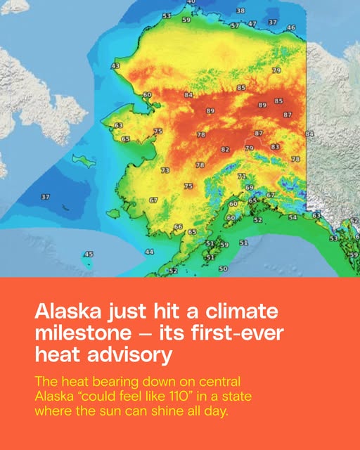
As summer approaches, New Hampshire is expected to experience an intense heat wave, marking the highest temperatures since last summer and potentially in several years, both duration and humidity levels. The first full week of summer will feature temperatures in the 90s, accompanied by muggy conditions and heat indices exceeding 100 degrees. Heat wave will run Sunday through Wednesday making it a four-day heat wave!!
5-Day Outlook
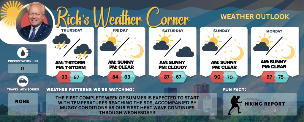
Today: Hot & muggy with sun & clouds; a couple of showers and a heavy thunderstorm in the afternoon; thunderstorms can bring hail and damaging winds. High 93 (feel like 97) Winds: SSW 10-20+ mph
Tonight: A spot thunderstorm during the evening, then partly cloudy & turning less humid by morning. Low 67 Winds: SW 10-20 mph
Friday (First day of summer): Mostly sunny, windy, & warm. High 84 Winds: WNW 15-25+ mph
Friday night: Mainly clear & comfortable. Low 63 Winds: W 10-15 mph
Saturday: Mainly sunny & very warm. High 87 Winds: W 5-10 mph
Saturday night: Partly to mostly cloudy and more humid with a with a shower late. Low 67 Winds: SSW 5-10 mph
Sunday: Some sun, muggy, & hot marks the start of our first heat wave!! High 90 (feel like 93) Winds: W 10-15+ mph
Sunday night: Clear, warm, and humid. Low 70 (feel like 72) Winds: SSW 5-10 mph
Monday: Hot & very muggy with some sunshine; hottest day since last summer; be sure to stay hydrated! High 97 (feel like 100) Winds: SW 5-15 mph
Monday night: Clear to partly cloudy very warm & muggy. Low 75 (feel like 77) Winds: SW 5-10 mph
Weather Patterns We’re Watching
The first complete week of summer is expected to start with temperatures reaching the 90s, accompanied by muggy conditions as our first heat wave continues through Wednesday!!
Get Out!
Take a Hike: Take a Hike: Take a Hike: Summits above 4,000 feet: Summits obscured in the morning, then summits in and out of clouds. Showers with a chance of thunderstorms in the afternoon. Some thunderstorms may produce gusty winds, small hail, and heavy rainfall in the afternoon. Highs in the lower 70s… except in the mid 60s at elevations above 5000 feet. Southwest winds around 20 mph increasing to around 30 mph in the afternoon. Gusts up to 50 mph. Chance of rain 80 percent. Elevations between 2,500 and 4,000 feet: Summits obscured. Showers with a chance of thunderstorms in the afternoon. Some thunderstorms may produce gusty winds, small hail, and heavy rainfall in the afternoon. Highs in the mid 70s. Southwest winds 10 to 20 mph with gusts up to 45 mph. Chance of rain 90 percent.
Hit the Beach Hampton & Rye Beach Weather: Partly sunny. Patchy fog. A slight chance of showers. UV Index: Very high. Thunderstorm Potential: None. High Temperature: In the lower 80s. Winds: South winds 5 to 10 mph. Surf Height: Around 2 feet. Water Temperature: 59 degrees. According to the USCG, when the water temperature is below 60 degrees, the average submerged person could lose dexterity within minutes and be unable to accomplish simple tasks like buckling a life jacket or operating a radio. Rip Tide Current Risk: Low. Tides Hampton Beach: Low 0.2 feet (MLLW) 12:20 PM.
Jump in a Lake Weirs Beach for Bike Week: Southwest winds around 5 mph increasing to around 15 mph with gusts up to 25 mph in the afternoon. Waves around 1 foot building to 2 to 4 feet in the afternoon. Areas of fog in the morning. Mostly cloudy in the morning, then mostly sunny with a chance of showers and thunderstorms in the afternoon. Some thunderstorms may produce gusty winds, small hail, and heavy rainfall in the afternoon. Warmer with highs in the mid 80s. Chance of rain 50 percent. Water temperature 63 degrees.