
Rick Gordon’s Weather Watch
Follow our YouTube channel here.
Today’s Weather
Hazy sun and sky due to high-altitude smoke from distant Canadian fires, hot with the start of the third heat wave, and muggy. High of 93 (feels like 100). Winds from the southwest at 5 to 10 mph.
Weather Alerts
Today marks the beginning of our third heat wave, accompanied with a hazy sky due to high-altitude smoke originating from distant Canadian wildfires. This heat wave is anticipated to last until Friday.
5-Day Outlook
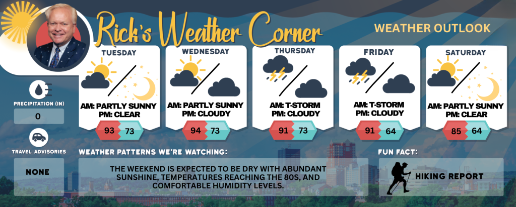
Today: Hazy sun; a hazy sky due to high altitude smoke from distant fires, hot (the start of or 3rd heat wave), and muggy. High 93 (feel like 100) Winds: SW 5-10 mph
Tonight: Clear, warm, and humid. Low 70 (feel like 74) Wind: Light & Variable
Wednesday: Mostly sunny, muggy, and hot; caution advised if outside for extended periods of time. High 94 (feel like 100) Winds: SW 5-10 mph
Wednesday night: Clear to partly cloudy, warm, and humid. Low 73 (feel like 78) Winds: SSW 5-10 mph
Thursday: Hazy, hot, and muggy; a thunderstorm in spots in the afternoon High 91 (feel like 97) Winds: SW 5-15+ mph
Thursday night: Partly cloudy, humid, and warm. Low 73 (feel like 77) Winds: SSW 5-10 mph
Friday: Hazy, hot and humid; a couple of spotty afternoon thunderstorms. High 91 (feel like 94) Winds: W 5-15 mph
Friday night: Some clouds and turning less humid. Low 64 Winds: NNW 5-10 mph
Saturday: Comfortable with some sun & clouds. High 85 Winds: WSW 5-10 mph
Saturday night: Clear to partly cloudy. Low 64 Winds: Light & Variable
Weather Patterns We’re Watching
The weekend is expected to be dry with abundant sunshine, temperatures reaching the 80s, and comfortable humidity levels.
Get Out!
Take a Hike: Take a Hike: Summits above 4,000 feet: Mostly cloudy in the morning, gradually clearing later. Temperatures will reach highs in the lower 70s, except for elevations above 5000 feet, where highs will be in the upper 60s. Northwest winds will reach up to 10 mph, with gusts of up to 20 mph. Elevations between 2,500 and 4,000 feet: Partly cloudy skies in the morning, gradually becoming clear. Temperatures reaching the upper 70s. Westerly winds at speeds up to 10 mph, with gusts potentially reaching 20 mph.
Hit the Beach Hampton & Rye Beach
Weather: Cloudy conditions will prevail until 2 PM, after which mostly sunny skies anticipated. Areas of patchy are expected
UV Index: Moderate.
Thunderstorm Potential: None.
High Temperature: In the mid 70s.
Winds: South winds around 5 mph.
Surf Height: Around 2 feet.
Water Temperature: 64 degrees.
Rip Tide Current Risk: Low.
Tides Hampton Beach: Low -0.2 feet (MLLW) 08:55 AM. High 9.3 feet (MLLW) 03:19 PM.
Jump in a Lake Weirs Beach: Light and variable winds shifting to the west at approximately 5 mph in the afternoon. Waves measuring less than 1 foot. Patchy fog expected in the morning. Clear skies with temperatures around 90. Water temperature at 73 degrees.