
Rick Gordon’s Weather Watch
Follow our YouTube channel here.
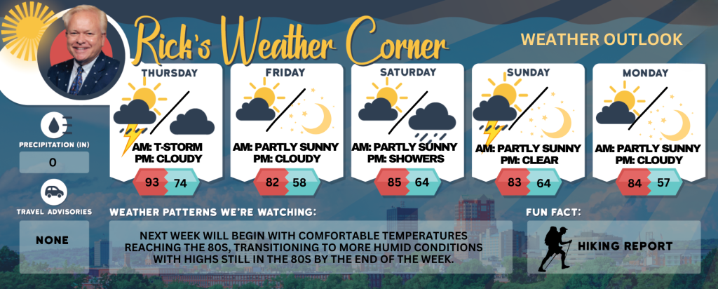
Today’s Weather
Hot and muggy with spot thunderstorms possible in the afternoon. These storms may cause flash flooding, hail, damaging winds, and even a tornado. High of 93°, feeling like 98°F. Winds: SW at 5-15+ mph.
5-Day Outlook
Today: Hazy, hot, and muggy; a thunderstorm in spots in the afternoon; storms can bring flash flooding, hail, damaging winds, and even a tornado. High 93 (feel like 98) Winds: SW 5-15+ mph
Tonight: Partly cloudy, humid, and very warm with a record low high tying the record of 74 set in 2006. Low 74 (feel like 77) Winds: WSW 5-10 mph
Friday: Times of sun and clouds, very warm, breezy, and turning less humid. High 82 Winds: NW 10-20 mph
Friday night: Clear and cooler. Low 58 Winds: NNW 5-10 mph
Saturday: Comfortable with some sun & clouds. High 85 Winds: WSW 5-10 mph
Saturday night: Partly to mostly cloudy with showers late. Low 64 Winds: Light & Variable
Sunday: Some sun and more humid with a thunderstorm in the afternoon. High 83 (feel like 86) Winds: WSW 5-10 mph
Sunday night: Clear to partly cloudy and humid. Low 64 Winds: Light & Variable
Monday: Lots of sunshine and less humidity. High 84 Winds: NW 5-10 mph
Monday night: Clear & cool. Low 57 Winds: N 5-10 mph
Weather Alerts
Heat Advisory Remains in Effect Until 8 p.m.

* WHAT: Heat index values in the upper 90s.
* WHERE: Eastern Hillsborough and Interior Rockingham Counties.
* WHEN: Until 8 PM this evening.
* IMPACTS: Hot temperatures and high humidity may cause heat illnesses.
PRECAUTIONARY/PREPAREDNESS ACTIONS: Drink plenty of fluids, stay in an air-conditioned room, stay out of the sun, and check up on relatives, neighbors and pets.
Weather Patterns We’re Watching
Next week will begin with comfortable temperatures reaching the 80s, transitioning to more humid conditions with highs still in the 80s by the end of the week.
Get Out!
Take a Hike: Summits above 4,000 feet: Summits shrouded intermittently by clouds. Scattered showers and thunderstorms are expected in the morning, followed by likely showers accompanied by thunderstorms in the afternoon. Certain thunderstorms may bring heavy rainfall, increasing the risk of flash flooding during the afternoon. Temperatures will reach highs in the upper 60s. South winds at10 15 mph, with gusts up to 30 mph. Probability of rain is 70 percent. Elevations between 2,500 and 4,000 feet: Summits obscured. Scattered thunderstorms in the morning. Numerous showers. Scattered thunderstorms in the afternoon. Some thunderstorms may produce heavy rainfall in the morning. Some thunderstorms may produce gusty winds and heavy rainfall that could produce flash flooding in the afternoon. Highs in the mid 70s. South winds up to 10 mph with gusts up to 30 mph. Chance of rain 70 percent.
Hit the Beach Hampton & Rye Beach
Weather: Partly sunny and humid, with scattered showers and thunderstorms.
UV Index: Very high.
Thunderstorm Potential: Moderate.
High Temperature: In the mid 80s (feeling like 91)
Winds: South wind 5-10 mph.
Surf Height: Around 2 feet.
Water Temperature: 65 degrees.
Rip Tide Current Risk: Low.
Tides Hampton Beach: Low 0.0 feet (MLLW) 11:02 AM. High 9.1 feet (MLLW) 05:04 PM.
Jump in a Lake Weirs Beach:
South winds at 5 to 10 mph. Waves approximately 1 foot. Numerous showers and scattered thunderstorms, with some potentially producing heavy rainfall in the morning. In afternoon, thunderstorms may bring gusty winds and heavy rainfall, which could result in flash flooding. Humid conditions with highs near 90. Chance of rain at 70 percent. Water temperature at 78 degrees.