
Rick Gordon’s Weather Watch
Follow our YouTube channel here.
Today’s Weather
Weather conditions today include hazy sunshine with high temperatures reaching 97°, feeling like 101° due to humidity. It is essential to stay hydrated and limit prolonged outdoor exposure to minimize the risk of dehydration and heatstroke.
5-Day Outlook
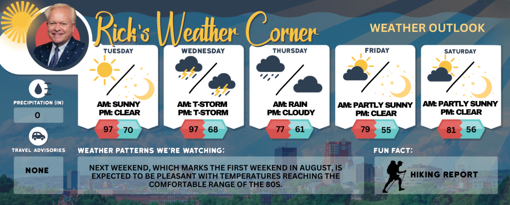
Today: Hazy sun, very hot, and humid; danger of dehydration and heatstroke if outside for extended periods of time. High 97 (feel like 101) Winds: NW 5-15 mph
Tonight: Mainly clear, warm, & humid. Low 70 (feel like 73) Winds: NW 5-10 mph
Wednesday: Partly sunny, humid, and very hot with spot thunderstorms in the afternoon; storms can bring flooding downpours and localized damaging wind gusts. High 97 (feel like 99) Winds: SW 5-10 mph
Wednesday night: Evening thunderstorm & humid. Low 68 Winds: W 5-10 mph
Thursday: Not as warm, accompanied by clouds with a couple of morning showers that gradually give way to lower humidity. High 77 Winds: NE 5-10 mph
Thursday night: Partial clearing late. Low 61 Winds: NE 5-10 mph
Friday (August 1st): Comfortable with some sun & clouds. High 79 Winds: NE 5-10 mph
Friday night: Some clouds & cool. Low 55 Winds: NNE 5-10 mph
Saturday: Mostly sunny & nice. High 81 Winds: NNW 5-10 mph
Saturday night: Clear & cool. Low 56 Winds: N 5-10 mph
Heat Advisory in effect from 11 a.m. to 8 p.m. Tuesday
The fourth heat wave of the summer will begin the work week, followed by a cool down with comfortable air arriving on Thursday and continuing into the first weekend of August. Today heat index values into the upper 90s to low 100s. Drink plenty of fluids, stay in an air-conditioned room, stay out of the sun and check up on relatives, neighbors, children, and pets.
Weather Patterns We’re Watching
Next weekend, which marks the first weekend in August, is expected to be pleasant with temperatures reaching the comfortable range of the 80s.
Get Out!
Take a Hike: Summits above 4,000 feet: Partly sunny with highs reaching the mid-70s, except in the mid-60s at elevations above 5,000 feet. Northwest winds at 25 to 35 mph, with gusts of up to 65 mph. Elevations between 2,500 and 4,000 feet: Partly sunny with temperatures reaching the upper 70s. Northwest winds between 10 to 20 mph, accompanied by gusts of up to 50 mph.
Hit the Beach Hampton & Rye Beach
Weather: Patchy morning fog followed by hazy sunshine.
UV Index: Very high.
Thunderstorm Potential: None.
High Temperature: In the upper 80s.
Winds: Southwest winds around 5 mph.
Surf Height: Around 1 foot.
Water Temperature: 62 degrees.
Rip Tide Current Risk: Low.
Tides Hampton Beach: Low 0.2 feet (MLLW) 09:35 AM. High 8.4 feet (MLLW) 03:33 PM.
Jump in a Lake
Weirs Beach: West winds at 5 to 10 mph. Waves approximately 1 foot. Patchy fog expected in the morning. Sunny and hot with temperatures reaching around 90 degrees. Water temperature is 74 degrees.