
Rick Gordon’s Weather Watch
Follow our YouTube channel here.
Today’s Weather
The first day of August is cloudy with spotty showers in the early morning, followed by clouds and sunshine in the afternoon. High temperature of 76°F. Winds: NE 5-10 mph.
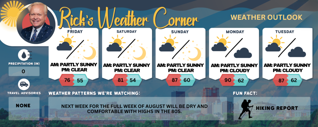
5-Day Outlook
Friday (August 1st): Cloudy with spotty showers in the early morning, followed by periods of clouds and sunshine in the afternoon. High 76 Winds: NE 5-10 mph
Friday night: Clearing & cool. Low 55 Winds: N 5-10 mph
Saturday: Mostly sunny & nice, a great start to the weekend. High 81 Winds: NNW 5-10 mph
Saturday night: Clear & cool. Low 54 Winds: Light & Variable
Sunday: Comfortable sunshine and warmer. High 87 Winds: WSW 5-10 mph
Sunday night: Clear. Low 60 Winds: SW 5-10 mph
Monday: Hazy sunshine & hot. High 90 Winds: WSW 5-10 mph
Monday night: Partly cloudy. Low 62 Winds: SW 5-10 mph
Tuesday: Some sun & clouds. High 87 Winds: SE 5-10 mph
Tuesday night: Partly cloudy. Low 62 Winds: SSE 5-10 mph
Summary of events for the first weekend of August
**Saturday: Get ready for a fantastic start to your weekend with mostly sunny skies and delightful temperatures. Expect a high of 81°, complemented by gentle winds from the NNW at 5-10 mph.
**Saturday Night: Enjoy a clear and refreshing evening, perfect for stargazing, with temperatures dropping to a cool 54°. Winds will be light and variable, adding to the serene atmosphere.
**Sunday: Embrace the warmth and comfort of a sunny day ahead! Temperatures will soar to a pleasant 87°, with refreshing winds from the WSW at 5-10 mph making it ideal for outdoor activities.
**Sunday Night: Wrap up the weekend under clear skies with a comfortable low of 60°. Winds will be from the SW at 5-10 mph, creating an inviting evening for relaxation.
Weather Patterns We’re Watching
Next week for the full week of August will be dry and comfortable with highs in the 80s.
Get Out!
Take a Hike: Summits above 4,000 feet: Summits covered in clouds. Temperatures reaching the upper 50s. Northeast winds at 10 to 15 mph, with gusts up to 25 mph. Elevations between 2,500 and 4,000 feet: Summits alternating between clear and cloudy skies. Temperatures peaking in the mid-60s. Easterly winds near 10 mph in the morning, shifting to light and variable in the day.
Hit the Beach Hampton & Rye Beach
Weather: Predominantly cloudy conditions will persist until 3 PM, followed by mostly sunny skies. There will be scattered showers in the morning.
UV Index: Moderate.
Thunderstorm Potential: None.
High Temperature: In the upper 60s.
Winds: Northeast winds around 10 mph.
Surf Height: 2 to 3 feet.
Water Temperature: 65 degrees.
Rip Tide Current Risk: Low.
Tides Hampton Beach: Low 1.4 feet (MLLW) 11:45 AM. High 8.1 feet (MLLW) 05:49 PM.
Jump in a Lake
Northeast winds at approximately 5. Waves under 1 foot. Partly sunny skies with patchy fog expected in the morning. A chance of rain in the morning, followed by isolated showers in the afternoon. High temperatures in the lower 70s. Rain probability at 40 percent. Thunderstorms are not anticipated during this period. Water temperature is 76 degrees.