
Rick Gordon’s Weather Watch
Follow our YouTube channel here.
Today’s Weather
Expect a day with more clouds than sunshine, as smoke from Canadian wildfires is likely to significantly impact air quality. The temperature will reach a high of 81 degrees, accompanied by gentle ESE winds at 5-10 mph. Stay informed and take precautions if you are sensitive to air quality issues.
5-Day Outlook
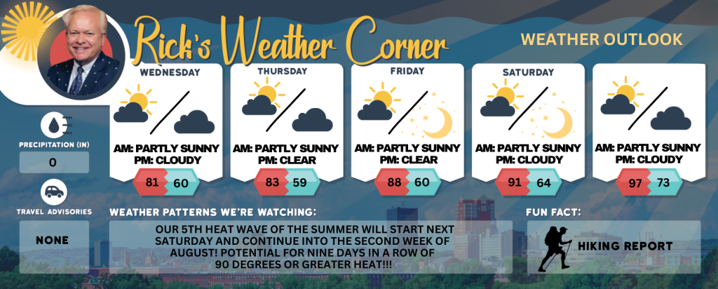
Today: More clouds than sun; smoke from wildfires in Canada can create reduced air quality. High 81 Winds: ESE 5-10 mph
Tonight: Mostly cloudy. Low 60 Winds: ESE 5-10 mph
Thursday: Some sun & clouds; smoke from wildfires in Canada can create reduced air quality. High 83 Winds: S 5-10 mph
Thursday night: Partly cloudy. Low 59 Winds: S 5-10 mph
Friday: Mostly sunny and very warm. High 88 Winds: SSW 5-10 mph
Friday night: Clear. Low 60 Winds: SSE 5-10 mph
Saturday: Hazy sunshine & hot. High 91 Winds: SSW 5-10 mph
Saturday night: Mainly clear. Low 64 Winds: SSW 5-10 mph
Sunday: Some sun, more humid, and very hot. High 97 (feel like 99) Winds: SW 5-15 mph
Sunday night: Partly cloudy, humid, and warm. Low 73 (feel like 75) Winds: SSW 5-10 mph
Futurecast
A significant high-pressure system will undoubtedly maintain dry and seasonable conditions in New Hampshire, providing comfortable air compared to the humid and hot summer experienced thus far. Smoke and hazy conditions will continue this week. The Canadian wildfires continue to rage and the smoke this week will continue to get into the atmosphere. Relish the upcoming week, as another heat wave is expected to arrive starting Saturday and persist into the second week of August. The second week of August is predicted to bring above-average temperatures, with the possibility of experiencing the fifth heat wave of the summer that could last nine days!!
Weather Patterns We’re Watching
Our 5th heat wave of the summer will start Saturday and continue into the second week of August!
Get Out!
Take a Hike: Summits above 4,000 feet: Mostly cloudy in the morning, with summits intermittently obscured by clouds. A chance of showers and thunderstorms is expected in the afternoon. High temperatures are expected to reach the lower 60s. Light and variable winds will become south around 10 mph in the afternoon. The probability of rain is 30 percent. Elevations between 2,500 and 4,000 feet: Summits intermittently shrouded in clouds. Temperatures reaching the upper 60s. Winds light and variable.
Hit the Beach Hampton & Rye Beach
Weather: Partial sunshine
UV Index: High.
Thunderstorm Potential: None.
High Temperature: In the lower 70s.
Winds: Northeast winds around 5 mph.
Surf Height: Around 2 feet.
Water Temperature: 65 degrees.
Rip Tide Current Risk: Low.
Tides Hampton Beach: High 7.1 feet (MLLW) 10:07 AM. Low 1.7 feet (MLLW) 04:08 PM.
Jump in a Lake
Light and variable winds shifting to southeast at approximately 10 mph in the afternoon. Waves about 1 foot. Partly sunny skies. High temperatures reaching the upper 70s. Water temperature at 75 degrees.