
Rick Gordon’s Weather Watch
Follow our YouTube channel here.
Today’s Weather
Partly cloudy with a hazy sun, feeling humid. Afternoon thunderstorms are possible. High of 87 degrees (feels like 93). Winds from the northwest at 5 to 10 mph.
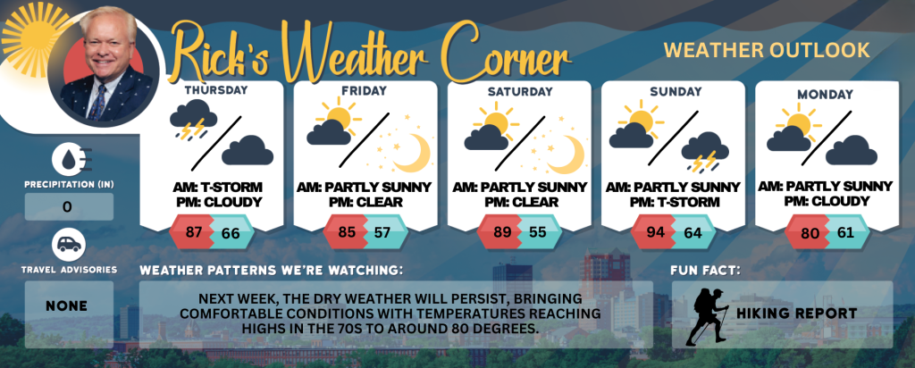
5-Day Outlook
Today: Hazy sun, not as hot, but humid with afternoon thunderstorms in spots. High 87 (feels like 93) Winds: NW 5-10 mph
Tonight: Partly cloudy and humid. Low 66 Winds: Light & Variable
Friday: Lots of sunshine and less humid. High 85 Winds: E 5-10 mph
Friday night: Mainly clear and comfortably cool. Low 57 Winds: SE 5-10 mph
Saturday: Mostly sunny and very warm. High 89 Winds: S 5-10 mph
Saturday night: Mainly clear and more humid. Low 65 (feel like 67) Winds: S 5-10 mph
Sunday: Some sun, hot, and humid. High 94 (feel like 96) Winds: WSW 5-10 mph
Sunday night: An evening thunderstorm and turning less humid. Low 64 Winds: NW 5-10 mph
Monday: Comfortable with a mix of sun & clouds. High Around 80 Winds: N 5-10 mph
Monday night: Clear to partly cloudy. Low 61 Winds: ESE 5-10 mph
Hurricane Erin Watch
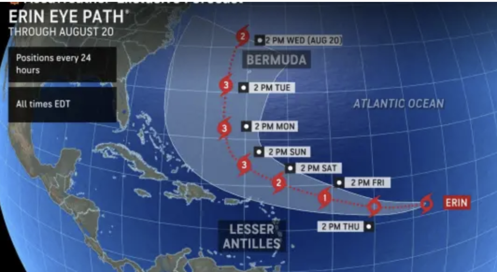
Erin is expected to strengthen and reach Category 3 hurricane intensity next week. Erin is expected to strengthen into a major hurricane, moving through the waters between Bermuda and the United States next week. Even without a direct hit on the U.S., the storm will bring significant risks to coastal areas with dangerous seas and surf.
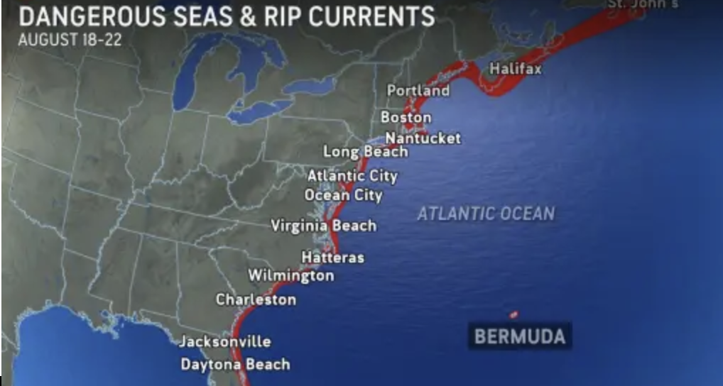
One thing is certain with Erin: dangerous surf and rip currents. As it intensifies, Erin is expected to grow larger, acting like a giant plunger on the Atlantic. This will generate massive swells that could travel hundreds of miles from its center. If Erin becomes strong and expansive enough, deep-sea swells might even reach heights of 50 feet or more.
Weather Patterns We’re Watching
Next week, the dry weather will persist, bringing comfortable conditions with temperatures reaching highs in the 70s to around 80 degrees.
Get Out!
Take a Hike: Summits above 4,000 feet: Summits covered in clouds. Morning showers are likely, followed by scattered thunderstorms and showers in the afternoon. Temperatures will reach the mid-60s, with northwest winds of 10 to 15 mph, gusting up to 30 mph. There’s a 60% chance of rain. Elevations between 2,500 and 4,000 feet: Mostly cloudy with scattered showers and thunderstorms. Temperatures reaching the lo
Hit the Beach Hampton & Rye Beach
Weather: Humid with sunshine and a few clouds; an afternoon thunderstorm in the area.
UV Index: Very High.
Thunderstorm Potential: Moderate.
High Temperature: In the upper 70s.
Winds: Southwest winds around 5 mph, becoming southeast in the afternoon.
Surf Height: Around 2 feet.
Water Temperature: 67 degrees.
Rip current rick: Low.
Tide Current Risk: Low -0.3 feet (MLLW) 09:47 AM. High 9.5 feet (MLLW) 03:46 PM..
Jump in a Lake
West winds around 5 mph with waves under 1 foot. Patchy fog expected in the morning. Showers and scattered thunderstorms are likely, with a 60% chance of rain. It will be humid, with highs in the lower 80s. The lightning threat is moderate, indicating possible thunderstorms. Water temperature is 76 degrees.