Rick Gordon’s Weather Watch
Follow our YouTube channel here.
Today’s Weather
Expect a milder day ahead with gusty breeze and periods of rain, bringing about 0.60 inches of moisture. The temperature will reach a high of 60 degrees, though it might feel a bit cooler at 55. Winds will be blowing in from the southeast at 10 to 20 mph, adding to that brisk vibe. Perfect weather for cozying up indoors or splashing through puddles!
Flood Watch
FLOOD WATCH IN EFFECT FROM MONDAY AFTERNOON THROUGH TUESDAY AFTERNOON.
* WHAT: Flooding caused by rain and snowmelt is possible.
* WHERE: New Hampshire, including the following areas, Belknap, Cheshire, Coastal Rockingham, Eastern Hillsborough, Interior Rockingham, Merrimack, Northern Carroll, Northern Coos, Northern Grafton, Southern Carroll, Southern Coos, Southern Grafton, Strafford, Sullivan and Western and Central Hillsborough.
* WHEN: From Monday afternoon through Tuesday afternoon.
* IMPACTS: Heavy runoff can lead to flooding in rivers, creeks, streams, and other low-lying or flood-prone spots. Areas with poor drainage and urban neighborhoods are also at risk, and low-water crossings might become submerged.
PRECAUTIONARY/PREPAREDNESS ACTIONS: Keep an eye on the latest forecast and stay alert for possible flood warnings. If you live in an area prone to flooding, be ready to take action if conditions worsen.
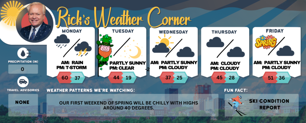
Today: Milder & breezy with periods of rain (.60″). High 60 (feel like 55) Winds: SSE 10-20 mph
Tonight: Windy with periods of rain (.60″), some heavy, and a thunderstorm; there can be ponding on roadways. Low 37 (feel like31) Winds: SSW 15-25+ mph
Saint Patrick’s Day: Mostly sunny, windy, and cooler. High 44 (feel like 35) Winds: W 15-25 mph
Tuesday night: Mainly clear, breezy, & much cold. Low 19 (feel like 7) Winds: WNW 10-20 mph
Wednesday: Mainly sunny & cold. High 37 Winds: W 5-10 mph
Wednesday night: Partly to mostly cloudy. Low 25 Winds: Light & Variable
Thursday: Mostly cloudy & not as cold. High 45 (feel like 39) Winds: S 10-15 mph
Thursday night: Mainly cloudy. Low 28 Winds: Light & Variable
Friday the first day of Astronomical Spring: Some sun and mild. High 51 Winds: WSW 5-10 mph
Friday night: Partly cloudy. Low 36 Winds: SSW 5-10 mph
Weather Patterns We’re Watching
Our first weekend of Spring will be chilly with highs around 40 degrees.
Get Out!
Elevations for summits above 4,000 feet in Northern New Hampshire today: Expect freezing rain in the morning, followed by steady rain with highs in the upper 40s. South winds will blow at 20 to 30 mph, while elevations above 5000 feet will see stronger winds around 50 mph, easing to about 40 mph in the afternoon. Gusts could reach up to 85 mph, with nearly a 100 percent chance of precipitation and wind chills as low as 1 degree above in the morning.
Elevations between 2,500 and 4,000 feet in Northern New Hampshire today: Expect freezing rain in the morning, followed by steady rain later on. Temperatures will reach the upper 40s, with southeast winds of 15 to 25 mph and gusts up to 60 mph. There’s nearly a 100 percent chance of precipitation, and wind chills could drop to as low as 9 degrees above.