Wednesday’s weather: Sunny and warmer, high of 75
read more…: Wednesday’s weather: Sunny and warmer, high of 75High pressure is expected to dominate our weather today straight into the weekend with building heat and humidity later in the week.

Posts by Rick Gordon
High pressure is expected to dominate our weather today straight into the weekend with building heat and humidity later in the week.
Rainy periods will end by evening. Drier air will gradually filter in from the north tonight with some sun and warmer tomorrow.

If you’re heading out today give yourself some extra time for rainy travel conditions. Rounds of rain could result in minor flooding of urban, low-lying, and poorly drained areas.

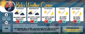
A front will slowly enter from the north today before stalling near southern New England on Labor Day providing a cool and rainy holiday.
High pressure slides across New Hampshire today bringing fair weather and a warming trend into the Holiday weekend. The next cold front crosses Sunday for another round of showers and possibly some thunderstorms with the front stalling over southern New England into Labor Day.
Today high-pressure slides across New Hampshire today and tomorrow with a warming trend into the Holiday weekend. The next cold front crosses Sunday for another round of showers and possibly some thunderstorms with the front stalling over southern New England into early next week.

High pressure builds in today through the upcoming Holiday Weekend, bringing a stretch of mainly dry and comfortable late summer weather.

Today a cold front moves offshore ushering much lower humidity levels. High pressure builds in tomorrow through the upcoming Holiday Weekend, bringing a stretch of mainly dry and comfortable late summer weather.

High pressure remains in control through the first part of the week. Mostly sunny today, as the flow, starts to turn more southwesterly, hotter, and more humid air to work back into New Hampshire.
High pressure is in control through tomorrow. Today will be another comfortable humidity day with temperatures slightly above normal. Tomorrow will feel the summer heat and humidity.

High pressure will usher in a cooler and drier airmass today. Look for continued comfortable conditions tomorrow with a slight increase in temperatures as southerly flow develops.

Thunderstorms late afternoon and evening might be strong to severe which could bring flash flooding and isolated damaging wind gusts. Overnight clearing and less humid during the day tomorrow.

Very warm and dry weather today and tomorrow, then a cold front may trigger scattered showers and strong thunderstorms tomorrow afternoon and evening.

Temperatures rebound to above normal for Wednesday in the mid-80s and lasts into the end of the week as high pressure builds across New England.

Today will be mostly cloudy and humid with scattered showers and thunderstorms. It will turn very warm again for the rest of the workweek, but oppressive heat is not expected.

The pattern turns unsettled early this week as a weak area of low-pressure crosses New Hampshire tonight and tomorrow with a good chance for rain showers and thunderstorms.

The high temperature yesterday was 94 just 1 degree from the record of 95 set in 1955. Today makes it our third day in a row with highs in the 90s making it an official heat wave. The high today will hit 92 with muggy conditions.

Near record heat today with a high of 94 with increasing humidity. Tomorrow will be an official heat wave with a high of 92 with muggy conditions.
Today will be a start of a heat wave with a high of 90. Both days this weekend temperatures into the lower 90s with increasing humidity.