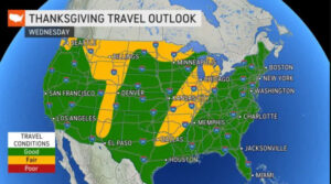
Tuesday’s weather: Some sun and clouds, high of 54
read more…: Tuesday’s weather: Some sun and clouds, high of 54Today lots of sun with a gusty westerly wind with highs near 60.
Posts by Rick Gordon
Today lots of sun with a gusty westerly wind with highs near 60.
Flashback: 10 years ago a record-breaking snowstorm spread across New England, bringing heavy snowfall, widespread power outages, and a once-in-a-lifetime White Halloween for many trick or treaters. The only White Halloween on record.
A trick-or-treat Halloween weekend headed our way. The trick will be today and tonight with showers to heavy rain. The treat will be on Halloween day with some sun & warmer conditions with highs in the mid-60s. Treat the wet leaves like ice or snow.
High pressure will allow for quiet weather today before our next storm system begins to approach from the south tomorrow.
A much brighter day is expected today as high pressure builds into the area from the west. High temperatures will be in the middle 50s. Northerly winds will still be gusty at times but should remain below 25 mph.
It will be windy today, but not as strong as last night. Our rain will taper off to showers this afternoon with a high around 50. Be aware when driving or walking that wet leaves can be very slick.
Today into tomorrow morning a nor’easter tracking off the southern New England coastline will bring a period of moderate to locally heavy rainfall along with windy conditions. Be aware when driving or walking that wet leaves can be very slick.
Rain with a strengthening northeasterly wind, especially along the coast. A round of more significant rain and stronger northeasterly winds arrives tomorrow and lingers into Wednesday morning.
Today will be even nicer than yesterday, with more sun and less wind with highs near 60. Tonight will cloud up with rain moving in after midnight.
Much cooler this weekend along with mainly dry weather. Highs both days in the 50s. The brightest of the two days will be Sunday.
One more warm day with highs around 70. Mostly dry but much cooler this weekend with highs in the 50s.
Surface high pressure that has been building across the southeastern United States moves offshore today allowing temperatures to hit the mid-70s. The high yesterday was 74, the record 74 set in 1953 and 2012.
Yesterday’s gusty northwesterly winds will diminish today as high pressure builds in. We’ll have a decent warm-up today with plenty of sun with a high of 70 that should last until Friday.
The upper-level low pressure responsible for the cooler conditions will hang around today before moving out. This low will also bring snow showers to the highest summits of the White Mountains.
An upper-level low will bring cool temperatures for today and tomorrow with highs in the 50s. The chilliest night of the season tonight with a low of 40, some upper 30s in the valleys.
The strong cold front that moved through last night will usher in some sun and cooler air on a gusty wind today.
Today will feature one more day of unseasonably mild temperatures with highs in the 70s. A cold front will bring scattered showers & perhaps a thunderstorm tonight.
Today a warm front will set up over southern New Hampshire. This will keep temperatures warm south of the front, but much cooler and cloudy to the north of it.
Getting back to real October weather next week.