Wednesday’s weather: Sunny and nice, high of 74
read more…: Wednesday’s weather: Sunny and nice, high of 74Temperatures will warm into the mid-70s today with early summer-like warmth Thursday and Friday.

Temperatures will warm into the mid-70s today with early summer-like warmth Thursday and Friday.

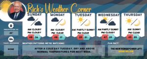
Today will be cooler with some sun & clouds and a high in the mid-60s. Temperatures tomorrow warm into the 70s followed by highs around 80 Thursday and Friday!
Today will be sunny and nice with slightly cooler temperatures with a high near 70. A back door cold front will deliver temperatures in the mid-60s tomorrow.
Another beautiful day is on tap to close out the weekend with sunshine through mid-high clouds & highs in the low 70s.
Today high pressure builds west of New England, yielding a dry and warm northwest flow for the weekend with highs on both days in the lower 70s.

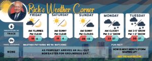
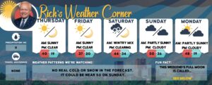
Spring weather is right around the corner after today’s high of 57, the weekend temperatures will be around 70 degrees.
Today will continue to be dreary & cool with on-and-off spot showers. The good news is that drier and warmer weather looks to return this weekend and perhaps into next week!
A slow-moving upper-level low-pressure system will keep the weather unsettled and cool over the next few days. Precipitation will be showery and shouldn’t persist for an extended period at any one particular location.
Highs today will be a good 10 degrees colder than yesterday with a few showers. The unsettled weather will continue for the rest of the week.

Another upper low will establish itself over the Great Lakes into the middle of the week, sending multiple disturbances through the area and keeping chances of wet weather with temperatures through Friday in the 50s. Today will be the exception with some sun with highs in the mid-60s.

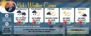
Another upper low will establish itself over the Great Lakes into the middle of next week, sending multiple disturbances through the area and keeping chances of rain in the forecast every day through next Friday. The heaviest rain Sunday night with 1.5-2″ of rain and gusty wind over 30 mph.
Another upper low will establish itself over the Great Lakes this weekend into the middle of next week, sending multiple disturbances through the area and keeping chances of rain in the forecast every day through next Friday. The heaviest rain Sunday night with 1.5-2″ of rain and gusty wind over 30 mph.

Today a brief break in the dreary weather pattern arrives as a ridge of high-pressure shifts over New England. Another upper low will establish itself over the Great Lakes this weekend into the middle of next week, sending multiple disturbances through the area and keeping chances of rain in the forecast every day through next Friday.
Today a series of disturbances rotating around a low-pressure aloft will bring scattered showers along with some sun with highs in the upper 50s.
The unsettled weather pattern continues today and tomorrow, with cool temperatures along with isolated and widely scattered showers. Not a washout with many hours of dry weather each day.
Low clouds this morning slowly lift and will give way to some breaks of sunshine this afternoon. Compared to yesterday more widespread hit-or-miss showers today.
Our weather pattern today remains unsettled which will last through the week, with daily opportunities for isolated to scattered rain showers. Temperatures will be below normal. Yesterday 1.92″ of rain was record-breaking, the old record of 1.09″ set in 2012.

Weather update: Flood advisory in effect until 7 p.m.
High pressure remains over the western Atlantic keeping New Hampshire mostly sunny today. Becoming cloudy tonight with a cloudy and cool start to the weekend with heavy chilly rain for Sunday.

High pressure remains over the western Atlantic keeping New Hampshire mostly sunny today. Becoming cloudy tonight with a cloudy and cool start to the weekend with heavy chilly rain for Sunday.