Thursday’s weather: More showers, high of 53
read more…: Thursday’s weather: More showers, high of 53Today periods of showers become light rain by evening with a high of 53.

Today periods of showers become light rain by evening with a high of 53.

Today for the beginning of the partial eclipse at 2:15 will be clear with a temperature of 62. Maximum partial eclipse at 3:29 will be clear with a temperature of 61. The end of the partial eclipse at 4:30 will be mainly clear with a temperature of 62.

There’s good news and bad news if you’re planning to hop over the border to Maine for Monday’s total solar eclipse.

Today will be cloudy with sunny breaks with a high near 50 along with a chilly breeze.

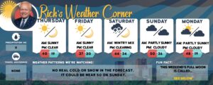
Today low pressure will linger in the Gulf of Maine for continued chances of rain & snow showers along with a chilly breeze with highs in the middle 40s but feeling like the upper 30s.

Scattered snow showers before 10 a.m., then a slight chance of rain showers after 1 p.m. Cloudy, with a high near 44. Northwest wind around 10 mph, with gusts as high as 20 mph. Chance of precipitation is 30%. New precipitation amounts of less than a tenth of an inch possible.

Today is windy with wet snow of varying intensity. Temperatures are nearly steady in the mid to upper 30s. Winds NE at 25 to 35 mph. An additional 2-4 inches of snow is expected. Winds could occasionally gust to near 50 mph causing blizzard-like conditions, power outages, and dangerous travel.
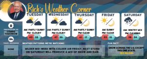
Cloudy today mild and dry with a high of 53. A complex storm system approaches Wednesday and will have the most impact Wednesday night into Thursday.

April Fool’s Day some sun & clouds with highs in the middle 50s with a light wind.

Easter the last day of March will produce a dawn snow or rain shower in spots for Easter sunrise services with sunrise at 6:29 with temperatures in the middle 30s. The afternoon some sun and breezy with a high of 53.

Cloudy with some afternoon sunny breaks and windy, winds could gust over 40 mph. Highs today around 50 but feeling like 41.

Today is mild with periods of rain (.70″) with a high of 52; there can be ponding on roadways.
Considerably milder today with a high in the middle 50s with a few showers. A frontal wave will bring more widespread rain Thursday into early Friday, which may lead to renewed flooding concerns.
Today will be cloudy with a chilly breeze making the high of 42 feel like it’s 35 degrees with the chance of some spotty drizzle.

Wet snow Saturday morning with an additional 1-2″ changing to heavy rain in the afternoon into the evening before rain changes to snow with an inch possible.

In honor of March being Colorectal Cancer Awareness Month, Bruttaniti was happy to share her story. “Saving even one person makes telling the story worth it. It’s a big deal. I’ve been telling everyone I know and I booked my husband an appointment, like, the day after.”
Sun will give way to afternoon clouds and cold with a high of 41 but feeling like the mid-30s. A storm system may affect the region with snow late Friday night and rain, possibly heavy on Saturday total snow is 1-3″ before it changes to rain. Ski country could receive over a foot of snow on Saturday.
Winter-like feel with some sun & clouds; a strong gusty wind of up to 42 mph making the high of 39 feel like it’s in the mid-20s.

The first full day of spring is breezy with lots of clouds with spot afternoon rain showers with highs in the upper 40s. Tonight, some early evening sprinkles or flurries and turning colder with lows in the upper 20s.