
Weather Watch with Rick Gordon
Click below for Rick’s exclusive videocast
Wednesday’s Weather
Expect cloudy skies with cooler temperatures, accompanied by a few showers, mainly later in the day. The high will be 75 degrees, feeling more like 80.
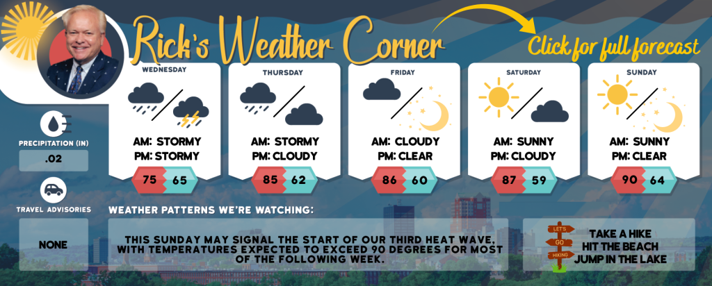
5-Day Forecast July 24-July 28
Today: Cloudy & humid, not as warm temperatures, but with a few showers primarily later in the day. High 75 (feel like 80) Winds: ESE 5-10 mph
Tonight: Cloudy and humid with a thunderstorm in spots. Low 65 Winds: SE 5-10 mph
Thursday: Expect a cloudy and humid day with afternoon showers and a thunderstorm; storms can bring flooding downpours and localized damaging wind gusts. High 85 (feel like 89) Winds: SW 10-15 mph
Thursday night: Partly cloudy and turning less humid. Low 62 Wins: WNW 5-10 mph
Friday: Mostly sunny, breezy, and comfortable. High 86 Winds: NW 10-15mph
Friday night: Mainly clear. Low 60 Winds: NW 5-10 mph
Saturday: Mostly sunny & nice. High 87 Winds: Light & Variable
Saturday night: Partly cloudy. Low 59 Winds: Light & Variable
Sunday: Mostly sunny, hot, and more humid. High 90 (feel like 95) Winds: SW 5-10 mph
Sunday night: Mainly clear and humid. Low 64 Winds: S 5-10 mph
Weather Patterns We’re Watching
This Sunday may signal the start of our third heat wave, with temperatures expected to exceed 90 degrees for most of the following week.
Hiking/Beach/Lake Forecasts
Take a Hike
Elevations for summits above 4,000 feet in Northern New Hampshire Today: The summits will be obscured with a possibility of showers. Expect highs around 60 degrees. South winds will be up to 10 mph, with gusts up to 20 mph. There is a 50 percent chance of rain.
Elevations between 2,500 and 4,000 feet in Northern New Hampshire Today: Expect cloudy skies with a possibility of showers. Temperatures will reach the mid-60s. Southeast winds will be gentle at up to 10 mph, with gusts potentially reaching 20 mph. There’s a 50 percent chance of rain.
Hit the Beach
- Weather: Overcast skies, intermittent fog, and a possibility of rain showers.
- UV Index: Moderate.
- Thunderstorm Potential: Low. Implies that there is little chance of thunderstorms.
- High Temperature: Around 70.
- Winds: East winds 5 to 10 mph.
- Water Temperature: 62 degrees.
- Surf Height: Around 2 feet.
- Rip Tide Current Risk: Low.
- Tides Hampton Beach: Low tide at -1.0 feet (Mean Lower Low Water) will occur at 08:26 AM, followed by a high tide of 9.1 feet (Mean Lower Low Water) at 02:25 PM.
Jump in a Lake
Expect east winds at approximately 5 mph with wave heights around one foot. The morning may bring patchy fog, followed by cloudy skies and a possibility of showers. The afternoon could see isolated thunderstorms. It will be humid with high temperatures in the lower 70s. There’s a 50 percent chance of rain. The threat of lightning is low, indicating a minimal chance of thunderstorms. The water temperature will be around 76 degrees.