
Rick Gordon’s Weather Watch
Follow our YouTube channel here.
Today’s Weather
Get ready for a delightful day! With a perfect blend of warm sunshine and fluffy clouds, there’s just a tiny possibility of a light shower. Expect a high of 79 degrees, and don’t forget to feel that refreshing breeze as winds whip in from the WSW at 15- 20+ mph. Enjoy your day!ing touch. Enjoy your day!
Weekend Breakdown
Saturday: Start your weekend with some morning rain (0.50 inches) that will give way to refreshing afternoon sunshine and exciting thunderstorms. Expect a high of 70°F with northwest winds at 10-15 mph, making for a dynamic day.
Saturday Night: As the sun sets, anticipate some early showers, leading to a low of 51°F. Winds from the west-northwest at 5-10 mph will create a crisp evening atmosphere.
Sunday (June 1st): Embrace a breezy day filled with a delightful mix of sun and clouds. With a high of 66°F and west winds at 15-20 mph, it’s a perfect opportunity for outdoor activities.
Sunday Night: Enjoy a clear and cool evening with temperatures dipping to 46°F. Winds from the west-southwest at 5-10 mph will add to the refreshing night air.
5-Day Outlook
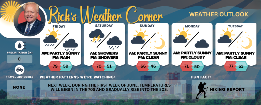
Friday: Warmer & breezy with sun & clouds, slight chance of a shower. High 79 Winds: WSW 15-20+ mph
Friday night: Cloudy with rain late. Low 59 Winds: SW 5-10 mph
Saturday: Morning rain (.50″) with some afternoon sun & thunderstorms. High 70 Winds: NW 10-15 mph
Saturday night: Some early showers. Low 51 Winds: WNW 5-10 mph
Sunday (June 1st): Breezy with some sun & clouds. High 66 Winds: W 15-20 mph
Sunday night: Clear & cool. Low 46 Winds: WSW 5-10 mph
Monday: Pleasant with a mix of sun & clouds. High 71 Winds: W 5-10 mph
Monday night: Partly cloudy. Low 50 Winds: Light & Variable
Tuesday: Mostly sunny & nice. High 77 Winds: WNW 5-10 mph
Tuesday night: Clear to partly cloudy. Low 53 Winds: SW 5-10 mph
Weather Patterns We’re Watching
Next week, during the first week of June, temperatures will begin in the 70s and gradually rise into the 80s.
Get Out!
Take a Hike: Summits above 4,000 feet: Summits obscured. Highs in the upper 50s… except in the lower 50s at elevations above 5000 feet. West winds 10 to 20 mph with gusts up to 40 mph. Elevations between 2,500 and 4,000 feet: Summits obscured in the morning, then summits in and out of clouds. Highs in the lower 60s. West winds 10 to 15 mph with gusts up to 35 mph.
Hit the Beach Hampton & Rye Beach Weather: Partly sunny. Patchy fog. UV index: Moderate. Thunderstorm Potential: None High Temperature: Around 70. Winds: Southwest winds 5 to 10 mph. Surf Height: Around 2 feet. Water Temperature: 52 degrees. According to the USCG, when the water temperature is below 60 degrees, the average submerged person could lose dexterity within minutes and be unable to accomplish simple tasks like buckling a life jacket or operating a radio. Rip Tide Current Risk: Low. SATURDAY: Surf height around 3 feet. Mostly cloudy. Rain and a slight chance of thunderstorms. Highs in the lower 60s. South winds around 5 mph. SUNDAY: Surf height around 3 feet. Partly sunny. A chance of rain. Highs in the lower 60s. West winds around 10 mph. MONDAY: Surf height around 2 feet. Mostly sunny. Highs in the mid 60s. Southwest winds around 5 mph.
Jump in a Lake Weirs Beach Southwest winds at approximately 10 mph Waves about 1 foot. Patchy fog expected in the. Partly sunny skies. Temperatures reaching lower 70s. Water temperature at 54 degrees.