
Rick Gordon’s Weather Watch
Follow our YouTube channel here.
Today’s Weather
Expect a mix of sun and clouds, with showers and a thunderstorm developing later in the day. Conditions will be very warm and humid, and the storms may bring heavy rainfall and damaging wind gusts. The high will reach 89°, feeling like 95°. Winds will be coming from the WNW at 5-10 mph. Stay prepared!
Heat Advisory in Effect until 8 p.m.
WHAT: Heat index values in the mid to upper 90s today.
WHERE…Strafford, Coastal Rockingham, Eastern Hillsborough, and Interior Rockingham Counties.
WHEN: From 11 AM to 8 PM Today.
IMPACTS: Hot temperatures and high humidity may cause heat illnesses.
PRECAUTIONARY/PREPAREDNESS ACTIONS: Drink plenty of fluids, stay in an air-conditioned room, stay out of the sun, and check up on relatives, neighbors, and pets.
5-Day Outlook
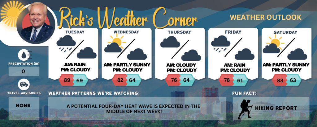
Today: Some sun with a couple of showers and a thunderstorm later in the day; very warm and humid; storms can bring flooding downpours and localized damaging wind gusts. High 89 (feel like 95) Winds: WNW 5-10 mph
Tonight: Mostly cloudy and humid. Low 69 (feel like 70) Winds: Light & Variable
Wednesday: Some sun and humid. High 82 (feel like 88) Winds: Light & Variable
Wednesday night: Some clouds and humid. Low 64 (feel like 62) Winds: Light & Variable
Thursday: Mostly cloudy, cooler, and a little less humid. High 76 Winds: ESE 5-10 mph
Thursday night: Partly cloudy. Low 64 Winds: E 5-10 mph
Friday: Cloudy with a passing shower. High 78 Winds: E 5-10 mph
Friday night: Partly to mostly cloudy and more humid. Low 61 (feel like 64) Winds: E 5-10 mph
Saturday: Mostly sunny, humid, and warmer. High 83 (fell like 90) Winds: E 5-10 mph
Saturday night: Partly cloudy and humid. Low 63 (feel like 66) Winds: ESE 5-10 mph
Weather Patterns We’re Watching
The upcoming weekend will begin with dry conditions and conclude with some showers, accompanied by temperatures reaching the 80s.
Get Out!
Take a Hike: Take a Hike: Summits above 4,000 feet: Summits obscured. Scattered showers. Scattered thunderstorms in the afternoon. Highs in the upper 60s… except in the lower 60s at elevations above 5000 feet. Northwest winds 10 to 15 mph with gusts up to 30 mph. Chance of rain 50 percent. Elevations between 2,500 and 4,000 feet: Cloudy. Scattered showers. Scattered thunderstorms in the afternoon. Highs around 70. Northwest winds up to 10 mph with gusts up to 25 mph. Chance of rain 50 percent.
Hit the Beach Hampton & Rye Beach
Weather: Partly sunny with a high likelihood of showers and scattered thunderstorms later in the day.
UV Index: Very high.
Thunderstorm Potential: Moderate.
High Temperature: In the lower 80s.
Winds: South winds at approximately 5 mph, shifting to the east in the afternoon.
Surf Height: Around 2 feet.
Water Temperature: 63 degrees.
Rip Tide Current Risk: Low.
Tides Hampton Beach: High 7.2 feet (MLLW) 10:41 AM. Low 1.7 feet (MLLW) 04:42 PM.
Jump in a Lake Weirs Beach: West winds approximately 5 mph. Waves under 1 foot. Partly sunny with scattered thunderstorms. Scattered showers expected in morning, to likely showers in the afternoon. Humid conditions with highs in the lower 80s. Probability of rain at 60 percent. Water temperature at 70 degrees.