Rick Gordon’s Weather Watch
Follow our YouTube channel here.
Weather Watch
Gloomy skies are expected to blanket the day, bringing a mix of rain and snow showers by the afternoon. Expect a high of 42 degrees, with light and variable winds adding a chill to the air. Be sure to grab your umbrella and dress warmly as you plan your day!
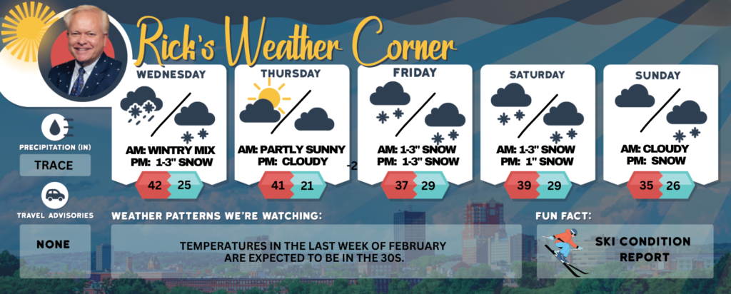
Today: Mainly cloudy with some rain or snow showers in the afternoon. High 42 Winds: Light & Variable
Tonight: Cloudy with periods of light snow and flurries with 1-2 inches of accumulation; be cautious of slippery areas. Low 25 Winds: Light & Variable
Thursday: Sunshine and some clouds. High 41 Winds light and variable.
Thursday night: Mainly clear & cold. Low 21 Winds: Light & Variable
Friday: Cloudy with periods of snow (1-3″) in the afternoon. High 37 Winds ENE at 5 to 10 mph
Friday night: Some snow (1-3″). Low 29 Winds: NNE 5-10 mph
Saturday: Cloudy with afternoon snow showers. High 32 (feel like 25) Winds: NNE 5-10 mph
Saturday night: Early flurries with some clearing late. Low 18 Winds: Light & Variable
Sunday: Mainly cloudy with snow by evening. High 35 Winds: NE 5-10 mph
Sunday night: Significant snowfall is expected, with the potential to exceed 5 inches. Low 26 Winds: NE 10-15+ mph
Weather Patterns We’re Watching
Temperatures in the last week of February are expected to be in the 30s.
Get Out!
Elevations for summits above 4,000 feet in Northern New Hampshire today: Summits will be hidden in the morning, with clouds drifting in and out throughout the day. Temperatures will peak in the lower 20s, with northwest winds around 30 mph easing to about 20 mph by afternoon. Gusts could reach up to 60 mph, and wind chill may drop as low as 15 below.
Elevations between 2,500 and 4,000 feet in Northern New Hampshire today: Summits will be hidden in the morning, then drift in and out of clouds. Highs will reach the mid-20s, with northwest winds at 10 to 20 mph and gusts up to 45 mph.