Wednesday’s weather: Passing shower, high of 72
read more…: Wednesday’s weather: Passing shower, high of 72Today is expected to be cloudy and cooler than yesterday, with a small chance of a brief shower and high temperatures in the low 70s.

Today is expected to be cloudy and cooler than yesterday, with a small chance of a brief shower and high temperatures in the low 70s.
Today’s forecast warmer temperatures; expect morning cloudiness, then intermittent clouds and sunshine in the afternoon with a high reaching 82 degrees.
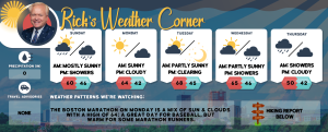
Next week is expected to be milder, with a growing chance of rain from Tuesday night to Wednesday, followed by predominantly dry and seasonal weather as the workweek comes to a close.
The morning will bring a blend of sunshine and clouds, transitioning to overcast skies in the afternoon. Expect a high of 58 degrees.

Today promises to be beautiful, with high pressure and a dry air mass creating warm and sunny conditions, culminating in a summer-like peak temperature of 77 degrees.

Cloudy skies with occasional evening showers and cool temperatures, reaching highs in the upper 50s.
Today and tomorrow high pressure north of New Hampshire will bring dry and cool weather with highs in the lower 60s with an onshore wind.
Today a cold front moves across New Hampshire with showers and perhaps isolated thunderstorm with a high of 57. Large high pressure will build into the region tomorrow through Saturday bringing dry weather with moderating temperatures Friday and Saturday.
A ridge of high pressure will result in dry weather today through Tuesday with cool days and nights, along with elevated fire weather potential.

Today a cold front will bring a period of showers this morning. Gradual partial clearing and pleasant temperatures are in store for later this afternoon with highs in the low 60s..
Dry and seasonable today with a high of 60. A cold front brings another round of showers tonight into early Saturday. Dry for the rest of Saturday with gusty winds. The dry stretch of weather continues as we head into early next week.
Today & tomorrow high pressure builds in with partly to mostly sunny skies along with a warming trend. Highs today and tomorrow in the middle 60s.
Today some morning sun will give way to clouds with showers by evening with a high of 60.
Today a few sunny breaks, windy, and cooler with a passing shower in spots with a high in the middle 50s.
Today will be mainly cloudy and cooler with a few passing showers this afternoon with a high in the upper 50s.
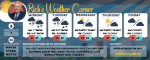
A Nor’easter will impact New England today through Thursday night timeframe. Today a mix of rain, snow, and sleet will change to wet snow tonight. Tonight is windy with periods of heavy wet snow (3-6″) with blizzard-like conditions with wind gusts over 40 mph, there can be power outages and dangerous travel.

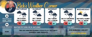
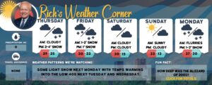
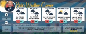
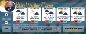
Weather Patterns We’re Watching: April snow next week? An April Nor’easter is possible next Wednesday into Thursday with blizzard-like conditions. The potential exists for 1-2 feet of snow!
Today some sunshine with a cold breeze with highs in the lower 40s but feels like the mid-30s.
The storm that brought snow to rain yesterday will push east of New Hampshire allowing for some sunshine along with a cold breeze making it feel like the middle 30s.
Today for the first day of Spring windy with some sun & clouds with a high of 44 but feeling like 37, more like winter. When Spring officially arrives at 11:06 tonight temperature will be 36 but feeling like freezing.