
Weather Watch with Rick Gordon
Click below for Rick’s exclusive videocast.
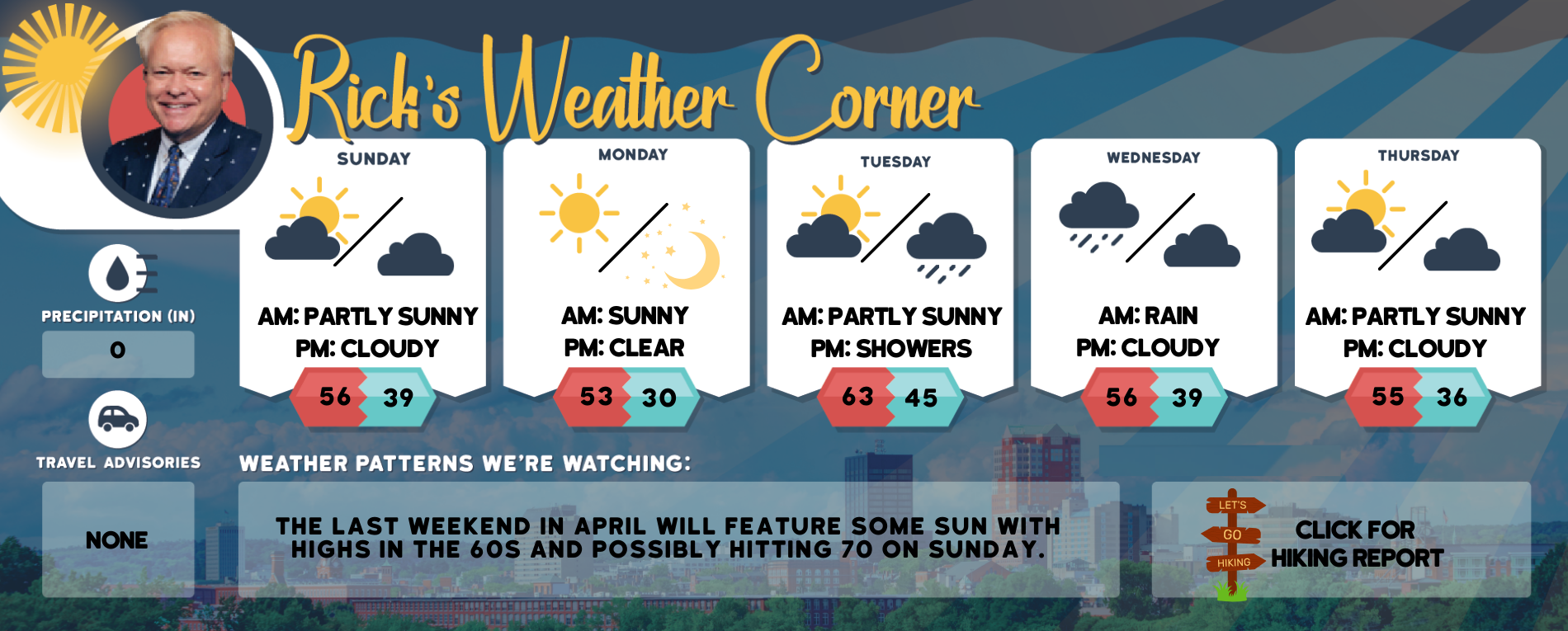
Sunday’s Weather
A ridge of high pressure will result in dry weather today through Tuesday with cool days and nights, along with elevated fire weather potential.
5-Day Outlook, April 21-April 25
Today: Breezy with some sun & clouds. High 56 Winds: W 15-20 mph
Tonight: Mainly clear & breezy. Low 39 Winds: W 10-15 mph
Monday: Sunny & cool. High 53 Winds: NW 10-15 mph
Monday night: Clear & cold. Low 30 (early vegetation can be damaged by a frost/freeze) Winds: WNW 5-10 mph
Tuesday: Breezy with some sun & clouds. High 63 Winds: SSW 10-20 mph
Tuesday night: Partly to mostly cloudy, breezy, and mild. Low 45 Winds: S 10-15 mph
Wednesday: Cloudy with some rain (.25″). High 56 Winds: SSW 10-15 mph
Wednesday night: Partly cloudy. Low 39 Winds: WNW 10-15 mph
Thursday: Some sun & breezy. High 55 Winds: NW 10-15 mph
Thursday night: Partly cloudy. Low 36 Winds: NW 5-10 mph
Early outlook for Summer
In the months of May-June-July temperatures are likely to be above normal. 
Weather Patterns We’re Watching
The last weekend in April will feature some sun with highs in the 60s and possibly hitting 70 on Sunday.

Hiking Report/White Mountains Weather
Elevations for summits above 4,000 feet in Northern New Hampshire Today: Summits in and out of clouds. Highs in the upper 30s… except around 30 at elevations above 5,000 feet. West winds 20 to 30 mph with gusts up to 55 mph. Wind chill values are as low as 3 below Cloudy. Highs in the lower 40s. West winds 10 to 20 mph with gusts up to 45 mph. in the morning.
Elevations between 2,500 and 4,000 feet in Northern New Hampshire Today: Cloudy. Highs in the lower 40s. West winds 10 to 20 mph with gusts up to 45 mph.

Click here to check out the current conditions at NH Ski Resorts!