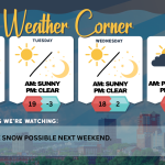
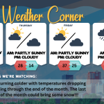
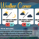
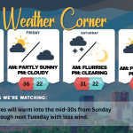
Monday’s weather: Cold and windy with drifting snow, high of 24 – overnight low around 0°

read more…: Monday’s weather: Cold and windy with drifting snow, high of 24 – overnight low around 0°

Today is windy with blowing and drifting snow, and it is colder with clouds gradually giving way to sunshine. Watch for slippery travel in the morning as a prolonged cold wave begins. Experience today’s high of 24 degrees, but don’t underestimate the wind—gusts over 30 mph will make it feel like just 7 degrees. Bundle up and stay warm!

Sunday’s weather: 6-8 inches of snow starting after 4 p.m. as Siberian cold front moves in, high of 37

read more…: Sunday’s weather: 6-8 inches of snow starting after 4 p.m. as Siberian cold front moves in, high of 37

New Hampshire is bracing for its first major snowstorm, with a Winter Storm Watch in effect from 4 PM Sunday until 7 AM Monday. Snow is expected to begin by 4 PM on Sunday and will continue until 7 AM on Monday. The storm will intensify, bringing strong winds from Sunday night through Monday and into Tuesday. Additionally, the storm’s circulation will pull in the coldest air of the winter, which has traveled all the way from Siberia.

Thursday’s weather: Cloudy and windy, morning flurries, high of 26

read more…: Thursday’s weather: Cloudy and windy, morning flurries, high of 26

Get ready for a dynamic start to your morning with a passing flurry but keep your guard up—the rest of the day will be dominated by mostly cloudy skies and strong winds, with gusts exceeding 40 mph at times. While the high will reach 26 degrees, it will feel more like a biting 7, so bundle up and stay warm!

Support Ink Link