
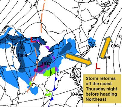
 MANCHESTER, NH — Enjoy the reprieve from shoveling, for now. The next wave of snow is expected to blow in sometime Thursday night, according to the National Weather Service.

Light snow across New Hampshire and Western Maine should add a few more inches to the most recent layer, which dumped another 12-14 inches across Hillsborough County and shut down schools for two days.
The wild card is still Saturday’s storm. It all depends on how the arctic winds blow, according to meteorologists, who we like to call “weather guessers” at times like this.
The biggest problem has been getting snow piles cleared to make way for plows and vehicles. Warmer temperatures Tuesday caused some melt, which will refreeze overnight Tuesday and could result in some icy patches for Wednesday, according to the weather service.
Below is the next week’s worth of weather at a glance from the Weather Underground, which includes the “potential snow storm” Saturday night, but otherwise, guaranteed consistently cold days, frigid nights and no spring weather in sight.
 Wednesday Night 0% Precip. / 0 inPartly cloudy skies. Low 1F. Winds light and variable.
 Thursday 60% Precip. / < 1 inCloudy with snow showers developing during the afternoon. High near 25F. Winds light and variable. Chance of snow 60%. Snow accumulations less than one inch.
 Thursday Night 60% Precip. / 1-3 inSnow showers will become more widely scattered later on. Low near 10F. Winds NNW at 10 to 20 mph. Chance of snow 60%. Snow accumulating 1 to 3 inches.
 Friday 10% Precip. / 0 inSome clouds in the morning will give way to mainly sunny skies for the afternoon. High 14F. Winds NW at 10 to 20 mph.
 Saturday 20% Precip. / 0 inCloudy. High 17F. Winds light and variable.Saturday Night 40% Precip. / ~ 1 inWatching a potential winter storm. Variable clouds with snow showers or flurries. Low 2F. Winds NNE at 10 to 20 mph. Chance of snow 40%. About one inch of snow expected.Sunday 20% Precip. / 0 inDecreasing cloudiness and windy. High 8F. Winds NNW at 20 to 30 mph.Sunday Night 10% Precip. / 0 inPartly cloudy. Low -3F. Winds NW at 15 to 25 mph.Monday 0% Precip. / 0 inSunshine and clouds mixed. High 14F. Winds NW at 10 to 20 mph.Tuesday 40% Precip. / < 1 inPartly cloudy skies during the morning hours will give way to occasional snow showers in the afternoon. High 23F. Winds SSW at 5 to 10 mph. Chance of snow 40%. Snow accumulations less than one inch.Tuesday Night 70% Precip. / 1-3 inSnow in the evening will transition to snow showers overnight. Low around 15F. Winds ENE at 5 to 10 mph. Chance of snow 70%. Snow accumulating 1 to 3 inches.Wednesday 20% Precip. / 0 inSunshine and clouds mixed. High 24F. Winds NW at 10 to 15 mph.