
Weather Watch with Rick Gordon
Below: Watch your weather outlook via YouTube, delivered in two minutes.
Friday’s Weather
Today is cloudy and humid with highs in the upper-70s with a couple of showers and a heavy thunderstorm; thunderstorms could bring damaging winds, flash flooding, and hail.

5-Day Outlook, Aug. 4 – 8
Today: Cloudy, cooler, & humid with showers and thunderstorms. High 78 (feel like 80) Winds: SSW 10-15 mph
Tonight: Humid with some evening showers and a thunderstorm. Low 63 Winds: SW 5-10 mph
Saturday: Mostly sunny & not as humid. High 82 Winds: NW 5-10 mph
Saturday night: Mainly clear & cool. Low 58 Winds: NNW 5-10 mph
Sunday: Some sun & clouds. High 83 (feel like 84) Winds: WNW5-10 mph
Sunday night: Partly cloudy. Low 61 Winds: SW 5-10 mph
Monday: Some sun & more humid with a strong afternoon thunderstorm. High 83 Winds: S 5-15 mph
Monday night: Mild & humid with some late thunderstorms. Low 67 Winds: S 5-15 mph
Tuesday: Humid & breezy with some sun & clouds; a stray afternoon thunderstorm. High 84 Winds: SSW 10-15 mph
Tuesday night: Mostly clear & humid. Low 63 Winds: WSW 5-15 mph
Weather Patterns We’re Watching
Next week for the first full week of August will be dry & humid with highs in the mid-80s.
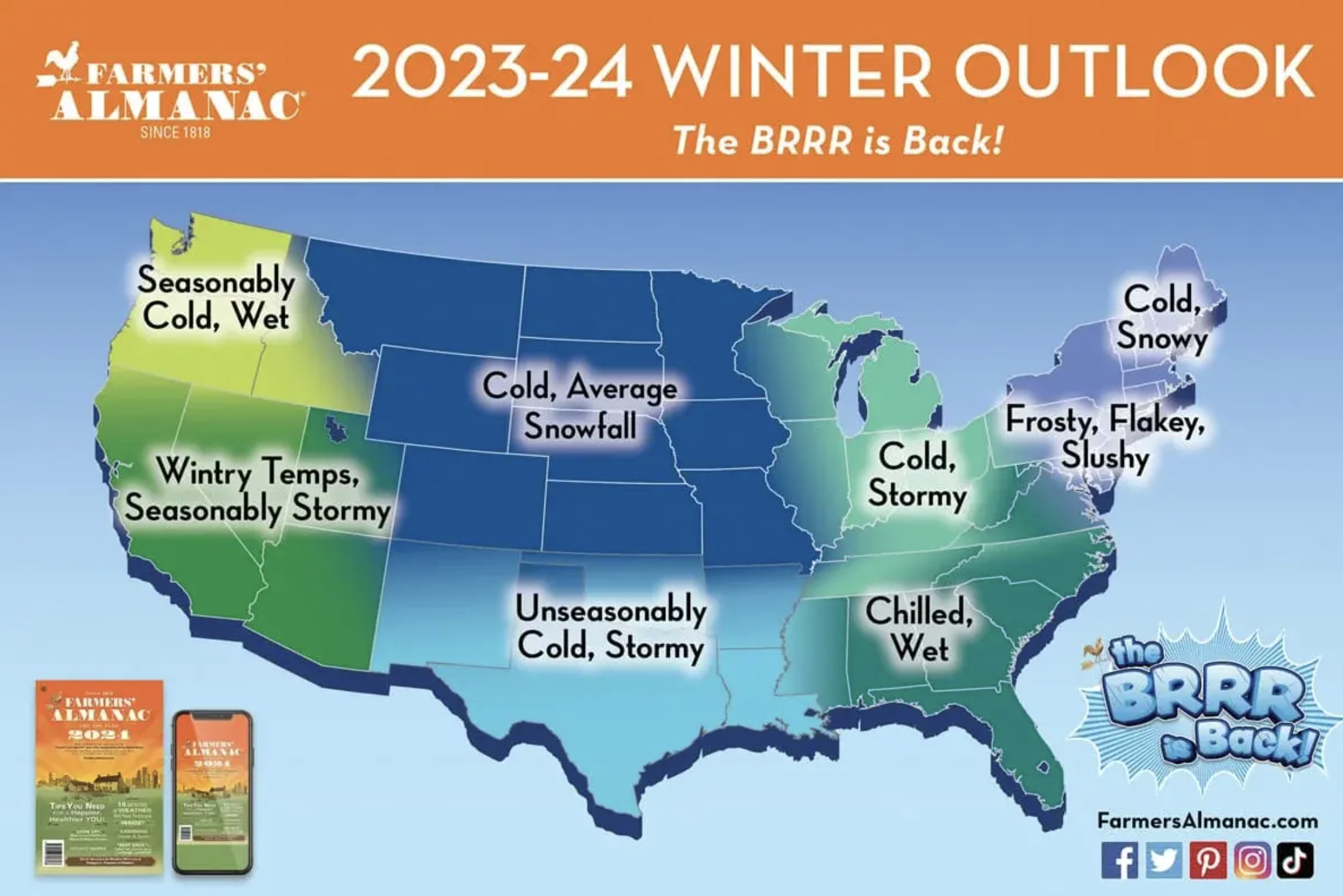
“The BRRR is Back!”
The Farmers’ Almanac is so confident that this winter will be cold across the country that their forecast has been dubbed ‘the BRRR is Back!’.
 Hiking Report/White Mountains Weather
Elevations for summits above 4,000 feet in Northern New Hampshire Today: Summits obscured. Showers with a chance of thunderstorms. Highs in the upper 50s. Southwest winds 10 to 20 mph. At elevations above 5,000 feet, west winds around 35 mph becoming southwest around 25 mph in the afternoon. Chance of rain 80 percent.
Elevations between 2,500 and 4,000 feet in Northern New Hampshire Today: Summits in and out of clouds. Showers with a chance of thunderstorms. Highs in the lower 60s. Southwest winds 10 to 15 mph with gusts up to 30 mph. Chance of rain 90 percent.

BEACH FORECAST
Weather: Mostly cloudy. Showers are likely and a chance of thunderstorms.
UV Index: Moderate.
Thunderstorm Potential: Moderate. Implies that thunderstorms are possible.
High Temperature: In the mid-70s.
Winds: South winds around 10 mph.
Surf Height: Around 3 feet.
Water Temperature: 65.
Rip Current Risk: Low.
Tides Hampton Beach: Low -1.3 feet (MLLW) 08:11 AM. High 9.5 feet (MLLW) 02:09 PM.
 View on Lake Winnipiseogee (1828) by American painter Thomas Cole
Lake Forecast
South winds around 10 mph. Waves around 1 foot. A chance of thunderstorms. Showers with highs in the lower 70s. Chance of rain 80 percent. The lightning threat is moderate, which implies that thunderstorms are possible. The water temperature is 75 degrees.