
Rick Gordon’s Weather Watch
Follow our YouTube channel here.
Today’s Weather
Experience a delightful mix of sun and clouds today, with warm temperatures making it feel just right. A gentle breeze will keep things comfortable as humidity levels begin to drop. Expect a high of 84 degrees, with northwesterly winds blowing at 10 to 20 mph. Perfect weather to enjoy the outdoors!
5-Day Outlook
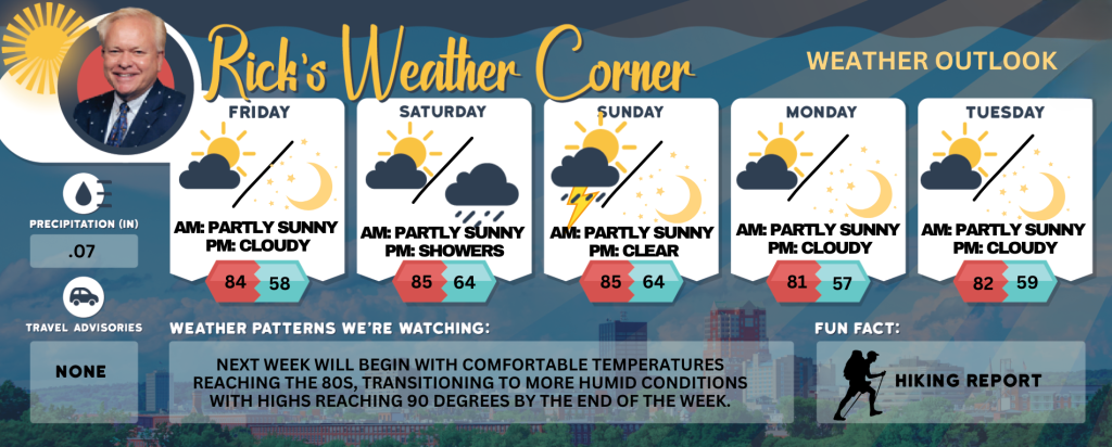
Friday: Times of sun and clouds, warm, breezy, and turning less humid. High 84 Winds: NW 10-20 mph
Friday night: Clear and cooler. Low 58 Winds: NW 5-10 mph Saturday: Comfortable with some sun & clouds. High 85 Winds: SW 5-10 mph
Saturday night: Partly to mostly cloudy with showers late. Low 64 Winds: Light & Variable
Sunday: Some sun and more humid with a few thunderstorms in the afternoon. High 85 (feel like 89) Winds: WSW 5-10 mph
Sunday night: Clear and humid. Low 64 Winds: Light & Variable
Monday: Lots of sunshine and less humidity. High 81 Winds: NNW 5-10 mph
Monday night: Clear & cool. Low 57 Winds: N 5-10 mph
Tuesday: Comfortable with some sun & clouds. High 82 Winds: SW 5-10 mph
Tuesday night: Clear & cool. Low 59 Winds: Light & Variable
Summary for Weekend Planning
🌤 Saturday Best Outdoor Window: Saturday daytime offers the most stable conditions for hiking, beach time, or cookouts.
⛈️ Sunday Caution Zone: Sunday afternoon may bring pop-up storms—ideal for indoor flexibility or early outdoor starts. Evening Notes: Both nights are mild, but Saturday night’s showers could dampen plans.
* WHAT: Heat index values in the upper 90s.
* WHERE: Eastern Hillsborough and Interior Rockingham Counties.
* WHEN: Until 8 PM this evening.
* IMPACTS: Hot temperatures and high humidity may cause heat illnesses.
PRECAUTIONARY/PREPAREDNESS ACTIONS: Drink plenty of fluids, stay in an air-conditioned room, stay out of the sun, and check up on relatives, neighbors and pets.
Weather Patterns We’re Watching
Next week will begin with comfortable temperatures reaching the 80s, transitioning to more humid conditions with highs reaching 90 degrees by the end of the week.
Get Out!
Take a Hike: Take a Hike: Summits above 4,000 feet: Summits will be obscured in the morning before clearing later in the day. High temperatures will reach the 50s. Northwest winds around 50 mph will decrease to approximately 35 mph by the afternoon, with gusts reaching up to 90 mph. Elevations between 2,500 and 4,000 feet: Summits will alternate between clouds and clear skies in the morning, followed by overall clearing. High temperatures will reach the mid-60s. Northwest winds will range from 20 to 30 mph, with gusts up to 70 mph.
Hit the Beach Hampton & Rye Beach
UV Index: Very high.
Thunderstorm Potential: None.
High Temperature: In the upper 70s.
Winds: Northwest winds 10 to 15+ mph.
Surf Height: Approximately 2 feet, decreasing to about 1 foot by the afternoon.
Water Temperature: 66 degrees.
Rip Tide Current Risk: Low. Tides Hampton Beach: Low 0.2 feet (MLLW) 11:53 AM. High 9.3 feet (MLLW) 05:57 PM.
Jump in a Lake Weirs Beach:
Weirs Beach: Northwest winds at approximately 15 mph, with gusts reaching up to 30 mph. Wave heights less than 1 foot at the northern end of the lake and around 1 foot at the southern end. Sunny skies with reduced humidity and temperatures in the mid-70s. Thunderstorms are not expected during this period. Water temperature is 75 degrees.