Rick Gordon’s Weather Watch
Follow our YouTube channel here.
Today’s Weather
Get ready for a uniquely mild day, where clouds dominate the sky, and showers are on the horizon! As temperatures climb to a high of 45 degrees, it may feel a crisp 35, so be sure to bundle up. Expect some light afternoon showers, about a tenth of an inch of rainfall. With a gentle south wind blowing at 5 to 15 mph, it’s the perfect excuse to grab your umbrella and embrace the invigorating weather.
Spring-like Weather
Springlike warmth will linger in New England through the middle of next week, but colder air is set to return, bringing the potential for a snowstorm by the end of the week and into next weekend.
If the storm moves up the coast, heavy snow might blanket the Appalachians and the northern and western suburbs of major I-95 cities in the Northeast. But if it shifts farther east, there could be little to no snow, with only a light dusting possible along parts of the mid-Atlantic coast. A second storm next weekend (Jan. 17-18) could follow a path that’s more likely to bring snow to the I-95 corridor in the Northeast.
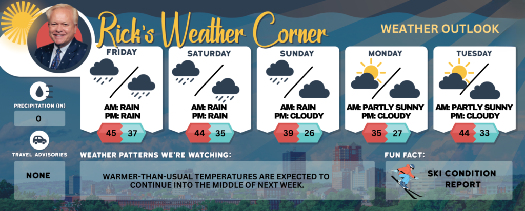
Friday: Cloudy and mild with some afternoon rain showers (.10″). High 45 (feel like 35) Winds: S 5-15 mph
Friday night: Cloudy with some evening rain showers (.10″). Low 37 (feel like 31) Winds: WSW 5-15 mph
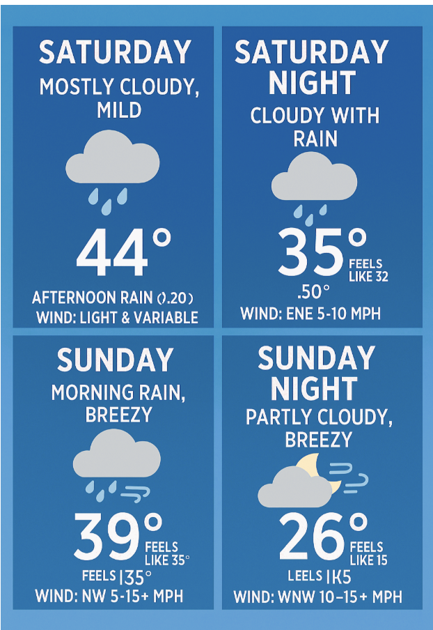
Saturday: Mostly cloudy & mild with some afternoon rain (.20″). High 44 Winds: Light & Variable
Saturday night: Cloudy with some rain (.50″) Low 35 (feel like 32) Winds: ENE 5-10 mph
Sunday: Some morning rain, breezy and cloudy during the afternoon. High 39 (feel like 35) Winds: NW 5-15+ mph
Sunday night: Partly cloudy, breezy, and cold. Low 26 (feel like 15) Winds: WNW 10-15+ mph
Monday: Mostly sunny, breezy, and colder. High 35 (feel like 25) Winds: WNW 10-20+ mph
Monday night: Partly cloudy and cold. Low 27 (feel like 25) Winds: WSW 5-10 mph
Tuesday: Some sun & clouds. High 44 (feel like 37) Winds: WSW 5-15 mph
Tuesday night: Some clouds. Low 33 Winds: SSW 5-10 mph
Weather Patterns We’re Watching
Warmer-than-usual temperatures are expected to continue into the middle of next week.
Get Out!
Elevations for summits above 4,000 feet in Northern New Hampshire today: The summits will be hidden with rain and freezing rain, and there’s a chance of snow in the afternoon. Temperatures will reach the mid-30s, with southwest winds around 40 mph, picking up to about 50 mph later. Gusts could hit 90 mph. There’s a 90% chance of precipitation, and wind chills may drop to around 10°F.
Elevations between 2,500 and 4,000 feet in Northern New Hampshire today: The mountain summits will be hidden, with rain and freezing rain likely, and a chance of snow later in the afternoon. Temperatures will reach the mid-30s, with southwest winds around 20 mph shifting to the south and increasing to about 30 mph. Gusts could hit up to 70 mph, with a 90 percent chance of precipitation. Wind chills may drop to as low as 9 degrees above zero