
Rick Gordon’s Weather Watch
Follow our YouTube channel here.
Today’s Weather
It will be less hot, with more clouds than sun. The day will be warm and humid, with spotty afternoon thunderstorms. These thunderstorms may bring localized damaging wind gusts. The high temperature will reach 81, but it will feel like 86. Winds will be from the east at 5 to 10 mph.
Weekend Outlook
Today, ahead of a slow-moving cold front, the weather will be less hot, with more clouds than sunshine. It will be warm and humid, with spotty strong afternoon thunderstorms possible. These thunderstorms may produce localized damaging wind gusts. The cold front is expected to remain stationary near New England from Friday through the weekend, bringing several waves of low pressure. This will result in daily chances of showers and storms. The weather is expected to much better on Sunday, with high pressure forecasted to briefly build in early next week.
5-Day Outlook
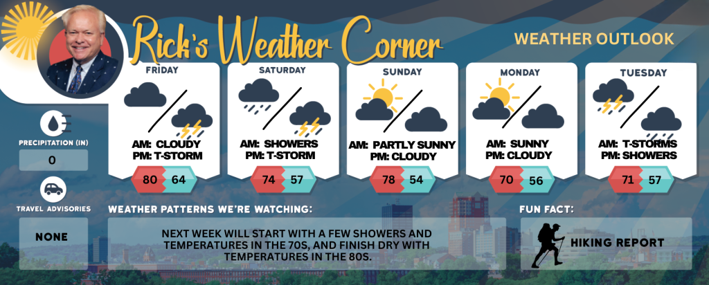
Friday: Not as hot with showers early, warm, & humid with spotty afternoon thunderstorms; thunderstorms can bring localized damaging wind gusts. High 80 (feel like 84) Winds: E 5-10 mph
Friday night: Mild and humid with periods of showers and a thunderstorm. Low 64 Winds: SE 5-10 mph
Saturday: Not as warm but humid with morning showers giving way to afternoon thunderstorms. High 74 Winds: SSW 5-10 mph
Saturday night: A couple of evening thunderstorms; otherwise, clearing and turning less humid. Low 57 Winds: Light & Variable
Sunday: Comfortable with some sun & clouds. High 78 Winds: ENE 5-10 mph
Sunday night: Partly cloudy. Low 54 Winds: Light & Variable
Monday: Some sun & clouds. High 70 Winds: ENE 5-10 mph
Monday night: Partly cloudy. Low 56 Winds: SE 5-10 mph
Tuesday: Cloudy with some showers and a spot thunderstorm. High 71 Winds: ESE 5-10 mph
Tuesday night: Evening showers. Low 57 Winds: SE 5-10 mph
Weather Patterns We’re Watching
Next week will start with a few showers and temperatures in the 70s, and finish dry with temperatures in the 80s.
Get Out!
Take a Hike: ake a Hike: Summits above 4,000 feet: Summits obscured. A chance of showers in the morning, then showers likely with a chance of thunderstorms in the afternoon. Some thunderstorms may produce gusty winds and heavy rainfall in the afternoon. Highs in the lower 60s. Northwest winds around 10 mph shifting to the southwest in the afternoon. Gusts up to 25 mph. Chance of rain 70 percent. Elevations between 2,500 and 4,000 feet: Summits obscured in the morning, then summits in and out of clouds. A chance of showers in the afternoon. Highs around 70. Light and variable winds. Gusts up to 20 mph. Chance of rain 50 percent.
Hit the Beach Hampton & Rye Beach Weather: Mostly cloudy. Patchy fog. A chance of showers and thunderstorms. UV index: Moderate. Thunderstorm Potential: Moderate. High Temperature: In the upper 60s. Winds: North winds around 5 mph, becoming east in the afternoon. Surf Height: Around 2 feet. Water Temperature: 52 degrees. According to the USCG, when the water temperature is below 60 degrees, the average submerged person could lose dexterity within minutes and be unable to accomplish simple tasks like buckling a life jacket or operating a radio. Rip Tide Current Risk: Low.
Jump in a Lake Weirs Beach Northeast winds around 5 mph shifting to the east in the afternoon. Waves less than 1 foot. Partly sunny with a chance of showers with a slight chance of thunderstorms in the morning, then mostly cloudy with showers likely with a chance of thunderstorms in the afternoon. Some thunderstorms may produce gusty winds and heavy rainfall in the afternoon. Not as warm with highs in the mid 70s. Chance of rain 70 percent. Water temperature 58 degrees.