
Weather Watch with Rick Gordon
Click below for Rick’s exclusive videocast
Friday’s Weather
Sunny and hot, not as muggy; however, there’s a risk of dehydration and heatstroke during intense activities. The high is 94 degrees, feeling like 98.
Weather Alert
Today is the seventh straight day of 90-degree weather, marking the second heat wave, with temperatures expected to remain at or above 90 degrees until next Wednesday.
5-Day Forecast July 12-July 16
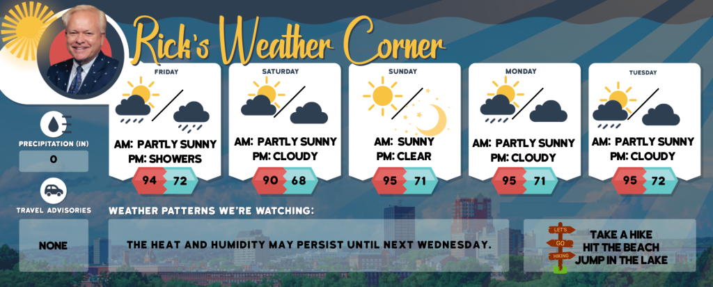
Today: Some sun, hot, and not as muggy; possible danger of dehydration and heatstroke while doing strenuous activities. High 94 (feel like 98) Winds: SW 10-15 mph
Tonight: Mostly cloudy and humid; periods of rain and a thunderstorm late. Low 72 Winds: SW 5-15 mph
Saturday: The clouds are parting to reveal a brighter sky, while the humidity persists along with a few showers and a thunderstorm. High 90 (feel like 96) Winds SSW 5-15 mph
Saturday night: Some clouds and humid. Low 68 Winds Light & Variable
Sunday: Mostly sunny, hot, and humid. High 95 (feel like 98) Winds W 5-10 mph
Sunday night: Mainly clear, warm, and humid. Low 71 Winds Light& Variable
Monday: Expect some sunshine, with hot and humid conditions. In the afternoon, watch for scattered thunderstorms which may lead to flash flooding and damaging winds. High 95 (feel like 99) Winds SW 10-15 mph
Monday night: Some clouds & humid. Low 71 Winds: SW 5-10 mph
Tuesday: Some sun, hot, & humid with a spot afternoon thunderstorm. High 95 (feel like 97) Winds: WSW 10-15 mph
Tuesday night: Some clouds, warm, & humid. Low 72 Winds: SW 5-10 mph
Weather Patterns We’re Watching
The heat and humidity may persist until next Wednesday.
Hiking/Beach/Lake Forecasts
Take a Hike
Elevations for summits above 4,000 feet in Northern New Hampshire Today: Expect summits to be shrouded in clouds at times. Temperatures will reach the upper 60s. Westerly winds will blow at 10 to 20 mph, with gusts possibly reaching 35 mph.
Elevations between 2,500 and 4,000 feet in Northern New Hampshire Today: Summits will weave in and out of clouds in the morning, followed by overcast skies. Expect highs in the lower 70s. Westerly winds will blow at 10 to 15 mph, with gusts reaching up to 30 mph.
Hit the Beach
- Weather: Sunny.
- UV Index: Very High.
- Thunderstorm Potential: None.
- High Temperature: In the lower 80s.
- Winds: Southwest winds around 10 mph.
- Water Temperature: 62 degrees.
- Surf Height: Around 3 feet.
- Rip Tide Current Risk: Low.
- Tides Hampton Beach: Low 0.9 feet (MLLW) 10:51 AM. High 8.0 feet (MLLW) 04:54 PM.
Jump in a Lake
Westerly winds at approximately 10 mph. Wave heights near one foot. Predominantly sunny skies. There’s a small chance of afternoon showers. It will be humid with high temperatures in the mid-80s. There is a 20 percent chance of rain. No thunderstorms are expected during this time. The water temperature is 74 degrees.