
Rick Gordon’s Weather Watch
Follow our YouTube channel here.
Today’s Weather
The first day of summer is here, bringing along a refreshing wind! Expect mostly sunny skies and a pleasant high of 84 degrees. With west-northwest winds blowing at 15- 25+ mph, it’s the perfect day to enjoy the outdoors and soak up the sunshine. Let the summer fun begin!
Weather Alert
Happy summer! New Hampshire is expected to experience an intense heat wave, marking the highest temperatures since last summer and potentially in several years, both duration and humidity levels. The first several days of summer will feature temperatures in the 90s, accompanied by muggy conditions and heat indices exceeding 100 degrees. Heat wave will run Sunday through Wednesday making it a four-day heat wave!!
5-Day Outlook
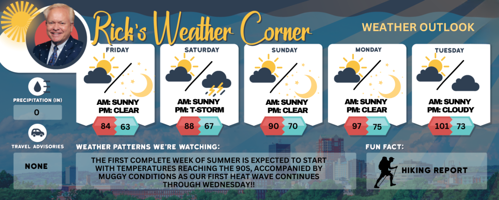
First day of summer: Mostly sunny, windy and not as hot. High 84 Winds: WNW 15-25+ (gusts up to 40mph)
Tonight: Mainly clear & comfortable. Low 63 Winds: W 10-15 mph
Saturday: Mainly sunny & very warm. High 88 Winds: W 5-10 mph
Saturday night: Partly to mostly cloudy and more humid with a thunderstorm late. Low 67 Winds: SSW 5-10 mph
Sunday: Some sun, muggy, & hot marks the start of our first heat wave!! High 90 (feel like 93) Winds: W 5-15+ mph
Sunday night: Clear, warm, and humid. Low 70 (feel like 72) Winds: Light & Variable
Monday: Hot & very muggy with some sunshine; hottest day since last summer; be sure to stay hydrated! High 97 (feel like 100) Winds: SW 5-15 mph
Monday night: Clear to partly cloudy very warm & muggy. Low 75 (feel like 77) Winds: SW 5-10 mph
Tuesday: Predominantly sunny extremely hot and muggy with temperatures surpassing the record of 95 degrees set in 2013; precautions are recommended for prolonged outdoor activities. High 101 (feel like 104) Winds: WNW 5-10 mph
Tuesday night: Partly cloudy, muggy, and warm. Low 73 (feel like 75) Winds: NW 5-10 mph
Weather Patterns We’re Watching
The first complete week of summer is expected to start with temperatures reaching the 90s, accompanied by muggy conditions as our first heat wave continues through Wednesday!!
Get Out!
Take a Hike: Summits above 4,000 feet: Summits obscured in the morning, then summits in and out of clouds. A chance of showers. Highs in the upper 50s… except in the lower 50s at elevations above 5000 feet. West winds around 45 mph becoming northwest and increasing to around 55 mph in the afternoon. Gusts up to 95 mph. Chance of rain 50 percent. Elevations between 2,500 and 4,000 feet: Summits obscured. A chance of showers. Highs in the lower 60s. West winds 25 to 35 mph with gusts up to 75 mph. Chance of rain 50 percent
Hit the Beach Hampton & Rye Beach Weather: Sunny. UV Index: Very high. Thunderstorm Potential: None. High Temperature: In the upper 70s. Winds: West winds 15 to 20+ mph. Surf Height: Around 3 feet. Water Temperature: 60 degrees. Rip Tide Current Risk: Low. Tides Hampton Beach: High 8.4 feet (MLLW) 06:48 AM. Low 0.3 feet (MLLW) 01:14 PM SATURDAY: Surf height around 2 feet. Sunny. Highs in the upper 70s. Southwest winds around 5 mph. SUNDAY: Surf height around 2 feet. Mostly sunny. A chance of showers. Highs in the upper 70s. Southwest winds around 10 mph. MONDAY: Surf height around 2 feet. Mostly sunny. Highs in the lower80s. South winds around 5 mph
Jump in a Lake Weirs Beach for Bike Week: West winds approximately 20 mph with gusts reaching up to 35 mph. Waves range from 3 5 feet at the north end of the lake and 4 to 5 feet at the south end. The weather is mostly sunny, less humid, with temperatures peaking in the mid-70s. The water temperature is 63.