
Weather Watch with Rick Gordon
Click below for Rick’s exclusive videocast
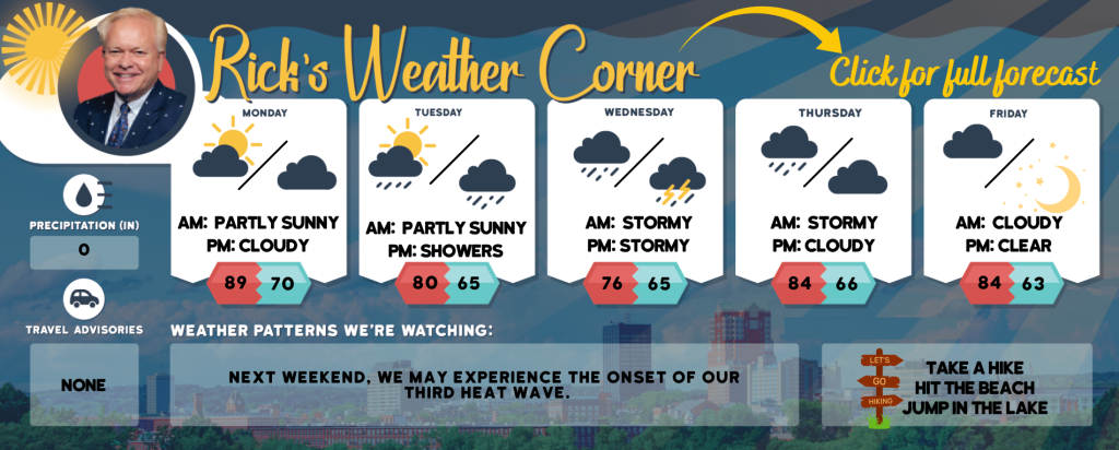
Monday’s Weather
Today very warm and comfortable with a blend of sunshine and clouds, reaching a high of 89 degrees.
5-Day Forecast July 22-July 26
Today: Very warm and comfortable with a mix of sun & clouds. High 89 Winds: SW 5-10 mph
Tonight: Becoming cloudy and turning more humid with a shower late. Low 70 Winds: SSE 5-10 mph
Tuesday: Expect alternating periods of clouds and sunshine, with humidity and occasional showers followed by a thunderstorm. High 80 (feel like 86) Winds: ESE 5-10 mph
Tuesday night: Cloud & humid with some spot thunderstorms. Low 65 Winds: SE 5-10 mph
Wednesday: Expect some sun & clouds, not as warm temperatures, but with humidity and occasional showers and a thunderstorm, primarily later in the day. High 76 (feel like 82) Winds: ESE 5-10 mph
Wednesday night: Cloudy and humid with a thunderstorm in spots. Low 65 Winds: SE 5-10 mph
Thursday: Expect a cloudy and humid day with afternoon showers and a thunderstorm. High 84 (feel like 89) Winds: SSW 5-10 mph
Thursday night: Partly to mostly cloudy and humid. Low 66 Wins: WSW 5-10 mph
Friday: Clouds giving way to some sunshine. High 84 (feel like 89) Winds: WSW 5-10 mph
Friday night: Mainly clear and a little less humid. Low 63 Winds: NW 5-10 mph
Weather Alerts
Temperature-wise, it’s expected to stay quite warm today and into the early week as humidity rises. Wednesday and Thursday may offer the only respite, with highs potentially nearing or slightly below average, accompanied by showers and thunderstorms. From Friday and heading into the next weekend, temperatures are predicted to climb once more with the return of sunshine with the potential for the start of our third heat wave.
Weather Patterns We’re Watching
Next weekend, we may experience the onset of our third heat wave.
Hiking/Beach/Lake Forecasts
Take a Hike
Elevations for summits above 4,000 feet in Northern New Hampshire Today: The morning will be mostly sunny, followed by periods of clouds. Expect highs in the mid-60s, although temperatures will hover around 60 at higher elevations above 5000 feet. West winds 10 to 15 mph with gusts up to 35 mph.
Elevations between 2,500 and 4,000 feet in Northern New Hampshire Today: Expect partial sunshine with highs around 70 degrees. Westerly winds will be gentle at 10 mph, but gusts may reach up to 25 mph.
Hit the Beach
- Weather: Mostly sunny.
- UV Index: Very high.
- Thunderstorm Potential: None.
- High Temperature: In the lower 70s.
- Winds: Northeast winds around 5 mph, becoming southeast in the afternoon.
- Water Temperature: 62 degrees.
- Surf Height: Around 1 foot, building to around 2 feet in the afternoon.
- Rip Tide Current Risk: Low.
- Tides Hampton Beach: Low tide at -0.6 feet (MLLW) will occur at 06:54 AM, followed by a high tide of 8.4 feet (MLLW) at 12:51 PM.
Jump in a Lake
Southwest winds will be approximately 5 mph with waves under one foot. The forecast is mostly sunny with temperatures reaching the lower 80s. No thunderstorms are expected during this period, and the water temperature will be around 77 degrees.