Rick Gordon’s Weather Watch
Follow our YouTube channel here.
Weather Watch
Get ready for an epic winter wonderland! A blizzard Nor’easter is blowing in today! Snow is expected, accompanied by gusty winds at times. The high temperature will reach 29, but it will feel like 11 due to the wind chill. Winds will be blowing from the north-northeast at 20 to 30 mph. Snow accumulation is estimated to be between 7 to 14 inches, making travel extremely difficult and dangerous. Wind gusts could occasionally exceed 50 mph, leading to blowing and drifting snow and possible power outages.
WINTER STORM WARNING

WHAT: Heavy snow expected. Total snow accumulations between 7 and 14 inches. Winds gusting as high as 40 mph.
WHERE: Portions of central and southern New Hampshire.
WHEN: Until 10 p.m. Monday.
IMPACTS: A snowstorm is set to bring plowable snow to the area, with moderate travel impacts expected. The main hazards will be periods of steady snow and low visibility. Snow bands could produce locally heavy snowfall, leading to quick accumulations and extremely dangerous travel. Significant snow and bursts of heavy snow, paired with low visibility, will make driving very hazardous. Blowing snow may also sharply reduce visibility. These conditions could affect Monday morning and evening commutes. Gusty winds might knock around unsecured items, break tree limbs, and possibly cause power outages.
PRECAUTIONARY/PREPAREDNESS ACTIONS: If you need to travel, make sure to keep an extra flashlight, some food, and water in your car in case of an emergency. You can check the latest road conditions by visiting newengland511.org. People should think about postponing any travel plans, and drivers should be extra careful if they must be on the road.
BLIZZARD WARNING IN EFFECT UNTIL TO 10 P.M.
WHAT: Blizzard conditions expected. Total snow accumulations between 7 and 14 inches. Winds gusting as high as 50 mph.
WHERE: Eastern Hillsborough and Interior Rockingham Counties.
WHEN: Until 10 PM tonight. IMPACTS: Whiteout conditions are expected with visibilities below 1/4 mile due to falling and blowing snow. The greatest potential for blizzard conditions will exist during the daylight hours today. The hazardous conditions will impact both the morning and evening commutes today. Strong winds will down tree limbs and blow around unsecured objects. A Few trees and power lines could be downed. The power outage threat is elevated.
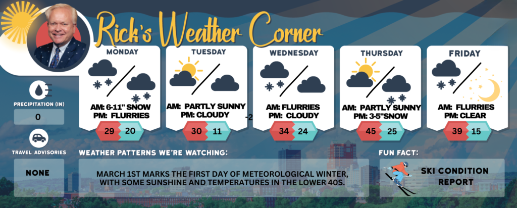
Today: Snow along with gusty winds at times. High 29 (feel like 11) Winds NNE 20 to 30 mph. Snow accumulating 6 to 11 inches; travel will be extremely difficult, and dangerous Winds could occasionally gust over 40 mph causing blowing and drifting snow.
Tonight: Cloudy and windy with a few snow showers or flurries. Low 20 (feel like 6) Winds: NW 15-25 mph
Tuesday: Breezy with some sun and cold. High 30 (feel like 18) Winds: WNW 10-20 mph
Tuesday night: Partly to mostly cloudy & cold. Low 11 Winds: Light & Variable
Wednesday: Cloudy with some flurries. High 34 Winds: SSW 5-10 mph
Wednesday night: Mostly cloudy. Low 24 Winds: Light & Variable
Thursday: Milder temperatures with a mix of clouds and sunshine, along with a few afternoon showers. High 45 (feel like 40) Winds: SW 5-15 mph
Thursday night: Cloudy with snow (3-5″). Low 25 Winds: Light & Variable
Friday: Morning flurries with some afternoon sun. High 39(feel like 31) Winds: NW 5-10 mph
Friday night: Clear and colder. Low 15 Winds: Light & Variable
Weather Patterns We’re Watching
March 1st marks the first day of Meteorological Winter, with some sunshine and temperatures in the lower 40s.
Get Out!
Elevations for summits above 4,000 feet in Northern New Hampshire today: Cloudy skies with blowing snow and periods of snowfall (3-5″). Visibility may drop to a quarter mile or less at times. Highs near 16 degrees, or around 10 above at elevations over 5,000 feet. Northeast winds will range from 25 to 35 mph, with stronger north winds of 45 to 55 mph at higher elevations. Snow is likely with a 90 percent chance, and wind chills could be as low as 28 below.
Elevations between 2,500 and 4,000 feet in Northern New Hampshire today: Expect cloudy skies with some patchy blowing snow. There’s a chance of snow in the morning, turning to steady snow (3-5″) by the afternoon. Visibility could drop to a quarter mile or less at times. Highs will be around 18°F, with northeast winds near 20 mph picking up to 30 mph from the north later in the day, and gusts reaching up to 60 mph. Snow chances are about 90%, and wind chills could feel as cold as -11°F.