Monday’s weather: Mostly cloudy, some showers likely, high of 79

Weather Watch with Rick Gordon

Below: Watch your weather outlook via YouTube, delivered in two minutes.
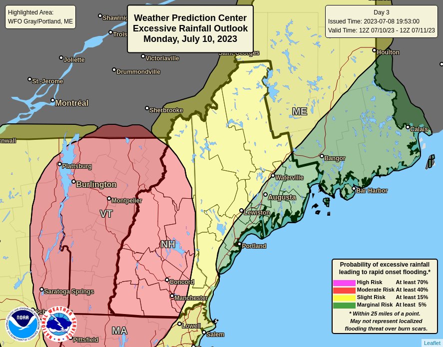

Monday’s Weather

This week will start out very wet. A low will move into New Hampshire today with significant rainfall possible, especially along the Connecticut River Valley. Flash flooding and river flooding is possible in New Hampshire.

How long does it take for your car to get HOT?

Even with car windows cracked, the temperature inside your vehicle can increase within minutes. CAR TEMPERATURE CHILD & PET SAFETY CHART.

Outside Temp. (F) Inside Temp (F) 10 mins. 30 mins.

70ย  ย  ย  ย  ย  ย  ย  ย  ย  ย  ย  ย  ย  ย  ย  ย  ย  ย  ย 89ย  ย  ย  ย  ย  ย  ย  ย  ย  ย  ย  ย  ย  ย  ย  ย  ย  ย  ย  ย  ย  ย  ย 104

75ย  ย  ย  ย  ย  ย  ย  ย  ย  ย  ย  ย  ย  ย  ย  ย  ย  ย  ย 94ย  ย  ย  ย  ย  ย  ย  ย  ย  ย  ย  ย  ย  ย  ย  ย  ย  ย  ย  ย  ย  ย  ย 109

80ย  ย  ย  ย  ย  ย  ย  ย  ย  ย  ย  ย  ย  ย  ย  ย  ย  ย  99ย  ย  ย  ย  ย  ย  ย  ย  ย  ย  ย  ย  ย  ย  ย  ย  ย  ย  ย  ย  ย  ย  ย 114

85ย  ย  ย  ย  ย  ย  ย  ย  ย  ย  ย  ย  ย  ย  ย  ย  ย  104ย  ย  ย  ย  ย  ย  ย  ย  ย  ย  ย  ย  ย  ย  ย  ย  ย  ย  ย  ย  ย  ย  ย 119

90ย  ย  ย  ย  ย  ย  ย  ย  ย  ย  ย  ย  ย  ย  ย  ย  ย  109ย  ย  ย  ย  ย  ย  ย  ย  ย  ย  ย  ย  ย  ย  ย  ย  ย  ย  ย  ย  ย  ย  124

95ย  ย  ย  ย  ย  ย  ย  ย  ย  ย  ย  ย  ย  ย  ย  ย  ย  ย 114ย  ย  ย  ย  ย  ย  ย  ย  ย  ย  ย  ย  ย  ย  ย  ย  ย  ย  ย  ย  ย  ย  129


5-Day Forecast July 10 – 14

Today: More clouds than sun & humid with some stray showers & thunderstorms late. High 79 (feel like 83) Winds: ESE 5-10 mph
Tonight: Evening thunderstorms and humid, then rain late. Low 69 Winds: SE 5-10 mph.
Monday: Humid with periods of rain (1″) and a spot thunderstorm; persistent downpours may lead to significant flooding. High 76 (feel like 79) Winds: E 5-10 mph
Monday night: Cloudy and humid with showers and a thunderstorm early. Low 67 Winds: Light & Variable
Tuesday: Cloudy & humid with some showers and thundershowers. High 83 (feel like 85) Winds: NNW 5-10 mph
Tuesday night: Partly cloudy & humid. Low 65 Winds: Light & Variable
Wednesday: Some sun, hot, & humid. High 90 (feel like 96) Winds: SW 5-15 mph
Wednesday night: Some clouds & humid. Low 67 Winds: Light & Variable
Thursday: Some sun, hot, & humid with a spot afternoon thunderstorm. High 91 (feel like 96) Winds: SSW 5-10 mph
Thursday night: Humid with spot thunderstorms & showers. Low 69 Winds: S 5-10 mph

Weather Patterns We’re Watching

Next Wednesday and Thursday will be hot & muggy with temperatures in the low 90s.


Hiking Report/White Mountains Weather

Elevations for summits above 4000 feet in Northern New Hampshire Today: Summits obscured. A chance of showers. A chance of thunderstorms in the afternoon. Some thunderstorms may produce heavy rainfall in the afternoon. Highs in the mid-60s. South winds 10 to 15 mph. Chance of rain 50 percent.

Elevations between 2,500 and 4,000 feet in Northern New Hampshire Today: Summits in and out of clouds. A chance of showers. A chance of thunderstorms in the afternoon. Some thunderstorms may produce heavy rainfall in the afternoon. Highs around 70. South winds up to 10 mph with gusts up to 20 mph. Chance of rain 50 percent.

BEACH FORECAST

Weather: Mostly cloudy. Patchy fog.

UV Index: Moderate.

Thunderstorm Potential: Low. Implies that there is little chance of thunderstorms.

High Temperature: In the lower 70s.

Winds: East winds 5 to 10 mph.

Surf Height: Around 2 feet.

Water Temperature: 64 degrees.

Rip Current Risk: Low.

Tides Hampton Beach: Low -0.4 feet (MLLW) 11:14 AM. High 9.2 feet (MLLW) 05:19 PM.

View on Lake Winnipiseogee (1828) by American painter Thomas Cole


Lake Forecast

Cloudy and not as warm but humid with a couple of showers and a heavy thunderstorm. High 77 Winds: ESE 5-10 mph. The water temperature is 72 degrees.


Sign up for the FREE daily newsletter and never miss another thing!

Subscribe

* indicates required

Support Ink Link