
Rick Gordon’s Weather Watch
Follow our YouTube channel here.
Today’s Weather
Expect a muggy day with a mix of sun and clouds, followed by a spot afternoon thunderstorm; some thunderstorms may produce heavy rainfall. The temperature will reach a high of 86 degrees, but it will feel more like 90 due to humidity. Winds will be coming from the south-southwest at 5-10 mph, so stay prepared for a warm and steamy day ahead!
Weather Alerts
The third heat wave is set to commence on Tuesday, accompanied by a hazy sky caused by high-altitude smoke from distant Canadian wildfires. This heat wave is expected to persist until Friday.
5-Day Outlook
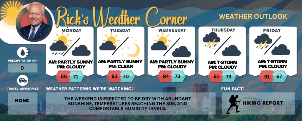
Today: Muggy with some sun & clouds with a spot afternoon thunderstorm. High 86 (feel like 90) Winds: SSW 5-10 mph
Tonight: Partly cloudy, warm, and humid. Low 71 (feel like 74) Winds: SSW 5-10 mph
Tuesday: Hazy sun; a hazy sky due to high altitude smoke from distant fires, hot (the start of or 3rd heat wave), and muggy. High 93 (feel like 100) Winds: Light & Variable
Tuesday night: Clear, warm, and humid. Low 70 (feel like 74) Wind: SSW 5-10 mph
Wednesday: Mostly sunny, muggy, and hot; caution advised if outside for extended periods of time. High 94 (feel like 100) Winds: SW 5-10 mph
Wednesday night: Clear to partly cloudy, warm, and humid. Low 73 (feel like 78) Winds: SSW 5-10 mph
Thursday: Hazy, hot, and humid; a thunderstorm in spots in the afternoon High 91 (feel like 97) Winds: SW 5-15+ mph
Thursday night: Partly cloudy, humid, and warm. Low 73 (feel like 77) Winds: SSW 5-10 mph
Friday: Hot and muggy with times of sun and clouds; a couple of afternoon showers and a thunderstorm. High 91 (feel like 97) Winds: W 5-15 mph
Friday night: Some clouds and turning less humid. Low 67 Winds: NNW 5-15 mph
Weather Patterns We’re Watching
The weekend is expected to be dry with abundant sunshine, temperatures reaching the 80s, and comfortable humidity levels.
Get Out!
Take a Hike: Summits above 4,000 feet: Summits will remain obscured. There is a chance of morning showers, followed by likely showers and potential thunderstorms in the afternoon. Some thunderstorms may bring heavy rainfall during the afternoon. Temperatures will reach highs in the mid-60s. Southwest winds will range from 10 to 15 mph, with gusts up to 30. The chance of rain is 70 percent. Elevations between 2,500 and 4,000 feet: Summits obscured. A chance of showers in the morning. A chance of thunderstorms. Showers likely in the afternoon. Some thunderstorms may produce heavy rainfall. Highs in the lower 70s. Southwest winds up to 10 mph with gusts up to 25 mph. Chance of rain 70 percent.
Hit the Beach Hampton & Rye Beach
Weather: Mostly cloudy skies with areas of patchy fog. There is a possibility of showers and thunderstorms.
UV Index: Moderate.
Thunderstorm Potential: Moderate.
High Temperature: In the upper 70s.
Winds: South winds 5 to 10 mph.
Surf Height: Around 2 feet, subsiding to around 1foot in the afternoon. Water Temperature: 63 degrees.
Rip Tide Current Risk: Low.
Tides Hampton Beach: Low -0.3 feet (MLLW) 08:46 AM. High 8.4 feet (MLLW) 02:45 PM.
Jump in a Lake Weirs Beach: South winds around 5 mph. Waves less than 1 foot. Mostly cloudy. Areas of fog in the morning. A slight chance of showers and thunderstorms in the morning, then showers likely with a chance of thunderstorms in the afternoon. Some thunderstorms may produce heavy rainfall. Humid with highs in the lower 80s. Chance of rain 70 percent. Water temperature 72 degrees.