
Rick Gordon’s Weather Watch
Follow our YouTube channel here.
Today’s Outlook
Today, June 1st, marks the start of meteorological summer. Expect early sun, then clouds and a couple of showers. High: 65°F. Winds: N 5-15 mph.
☀️ Meteorological Summer vs. Astronomical Summer
Meteorological Summer
Dates: June 1 – August 31
Defined by: Annual temperature cycle
Why it exists: Makes climate data easier to compare year‑to‑year
Aligns with the warmest three‑month period in the Northern Hemisphere
Used by: Meteorologists, Climatologists, NOAA, NWS, and most weather communication
Astronomical Summer
Dates: Vary slightly each year (around June 20–21 to September 22–23)
Defined by: Earth’s tilt and orbit
Starts: Summer Solstice (longest day of the year)
Ends: Autumnal Equinox (day and night roughly equal)
Used by: Astronomers/Cultural/seasonal traditions
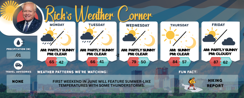
Today (June 1st, Start of Meteorological Summer.): Early sun followed by clouds & cool with a couple of showers. High 65 Winds: N 5-15 mph
Tonight: Clear & chilly. Low: 42 Winds: Light & Variable
Tuesday: Some early morning sun & cool. A few showers developing later in the day. High 66F. Winds N at 5 to 10 mph
Tuesday night: Becoming clear & chilly. Low 41 Winds: Light & Variable
Wednesday: Nice with a mix of sun & clouds. High 79 Winds: Light & Variable
Wednesday night: Mainly clear. Low 50 Winds: WSW 5-10 mph
Thursday: Mostly sunny & warm. High 84 Winds: WNW 5-10 mph
Thursday night: Mainly clear & mild. Low 57 Winds: W 5-10 mph
Friday: Very warm with some clouds & sun. High 87 Winds: WNW 5-10 mph
Friday night: Some clouds & mild. Low 62 Winds: SSW 5-10 mph
Weather Patterns We’re Watching
First weekend in June will feature summer-like temperatures with some thunderstorms.
Get Out!
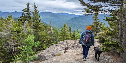
Take a HikE
Summits above 4,000 feet: The mountain summits will be obscured in the morning, with visibility varying as clouds move in and out. Expect scattered rain showers throughout the morning, with high temperatures around 50 degrees, dropping to the mid-40s at elevations above 5,000 feet. Northeast winds will range from 10 to 15 mph, with gusts reaching up to 30 mph. There is a 50 percent chance of rain.
Elevations between 2,500 and 4,000 feet: Mountains shrouded in morning mist, with peaks occasionally breaking through the clouds. Expect scattered rain showers throughout the morning, with highs reaching the mid-50s. Northeast winds will blow at speeds of up to 10 mph, with gusts reaching 20 mph. There is a 50 percent chance of rain.
Hit the Beach
Hampton & Rye Beach Weather:
Weather: Mostly cloudy until 1 PM, after which it will become sunny. There may be scattered showers throughout the day.
Thunderstorm Potential: None.
High Temperature: In the upper 50s.
Winds: Northeast winds 5 to 10 mph.
Surf Height: Around 3 feet.
Ocean Temperature: 53 degrees. According to the USCG, when the water temperature is below 60 degrees, an average submerged person could lose dexterity within minutes and be unable to perform simple tasks such as buckling a life jacket or operating a radio.
Rip Current Risk: Moderate.
Tides Hampton Beach: Low 0.2 feet (MLLW) 07:14 AM. High 7.7 feet (MLLW) 01:11 PM.
Jump in a Lake
Weirs Beach: Northeast winds around 5 mph. Waves around 1 foot. Mostly
cloudy with scattered showers in the morning, then mostly sunny in
the afternoon. Highs in the lower 60s. Chance of rain 50 percent.
Water temperature 55 degrees.
According to the USCG, when the water temperature is below 60 degrees,
the average submerged person could lose dexterity within minutes and
be unable to accomplish simple tasks like buckling a life jacket or
operating a radio.