Saturday’s weather: Rain changes to snow and travel conditions become dicey; winter weather advisory in effect

Saturday’s Weather

Low pressure strengthens as it moves into the Gulf of Maine today and then into the Canadian Maritimes tonight. This area of low pressure will bring widespread rain changing to snow in the afternoon, along with gusty winds that could top 45 mph.

Weather Alert

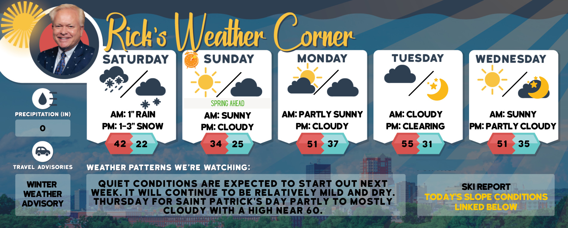
Rain changes to snow during the afternoon with quickly worsening travel conditions.


Travel Advisory

A Winter Weather Advisory in effect from 10 a.m. today-10 p.m. tonight.

What: Snow expected. Total snow accumulations of 2 to 5 inches are expected. Winds gusting as high as 45 mph.

Where: Portions of central, northern, and southern New Hampshire.

Impacts: Plan on slippery road conditions.

Additional details: Rain changes to wet snow late in the morning and early afternoon. Isolated power outages are possible due to the wet snow on tree limbs.

Precautionary/Preparedness Actions: Slow down and use caution while traveling.


๏ปฟ๏ปฟ๏ปฟ๏ปฟ๏ปฟ๏ปฟ๏ปฟ๏ปฟ๏ปฟ

5-Day Outlook March 12- March 16

Today: Rain (1โ€ณ) changing to snow in the afternoon & windy. Morning high 42 falling to 32 Winds: NNW 15-25+ mph
Tonight: Early snow (1-3โ€ณ) with partial clearing late, windy, and colder; watch for a freeze-up. Low 22 Winds: WNW 15-25+ mph (Turn clocks ahead 1 hour before you go to bed.)
Sunday: Mostly sunny, windy, and cold. High 34 (feel like 22) Winds: WNW 15-25 mph
Sunday night: Partly cloudy. Low 25 Winds: WSW 10-15 mph
Monday: Partly sunny and warmer. High 51 Winds: WSW 10-15 mph
Monday night: Mostly cloudy. Low 37 Winds: SW 5-10 mph
Tuesday: Mostly cloudy. High 55 Winds: W 10-15 mph
Tuesday night: Some clearing. Low 31 Winds: NW 5-10 mph
Wednesday: Mostly sunny. High 51Winds: WSW 5-10 mph
Wednesday night: Clear to partly cloudy. Low 35 Winds: S 5-10 mph

Weather Patterns We’re Watching

Quiet conditions are expected to start out next week. It will continue to be relatively mild and dry. Thursday for Saint Patrick’s Day partly to mostly cloudy with a high near 60.


Be an Official Ink Link Weather Spotter!

Rick Gordon could use your help. If you are interested in becoming a local weather spotter (all locations around NH) contact Rick atย gordonwx@comcast.netย and heโ€™ll walk you through the process!

Winter Weather Watcher says: Looks like snow on the horizon, again.

Ski Report via Ski NH

Summits above 4,000 feet in Northern New Hampshire Today:
Snow (8-12″). Snow may be heavy at times in the afternoon. Highs in the lower 30s. Southwest winds around 30 mph increase to the northwest around 45 mph in the afternoon. At elevations above 5000 feet, southwest winds around 45 mph become northwest and increase to around 65 mph in the afternoon. Chance of snow near 100 percent. Wind chill values as low as 24 below in the afternoon.
Elevations between 2,500 and 4,000 feet in Northern New Hampshire Today:
Snow (8-12″). Highs in the lower 30s. Southwest winds around 30 mph with gusts up to 40 mph increasing to the northwest around 45 mph with gusts up to 60 mph in the afternoon. Chance of snow near 100 percent. Wind chill values as low as 18 below in the afternoon.
Click below for ski conditions at your favorite resorts:


Sign up for the FREE daily newsletter and never miss another thing!

Subscribe

* indicates required

Support Ink Link