
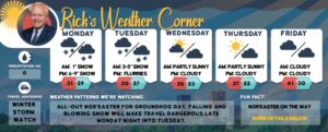
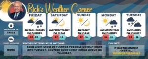
Tuesday’s weather: Cloudy and cooler with evening flurries possible, high of 39
read more…: Tuesday’s weather: Cloudy and cooler with evening flurries possible, high of 39Cold wintry weather is making a comeback.

Cold wintry weather is making a comeback.
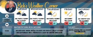
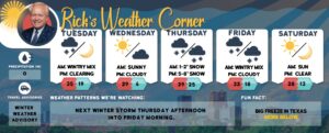
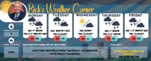
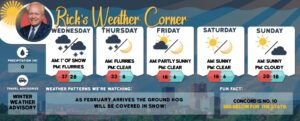
A significant winter storm is increasingly likely Wednesday night through Thursday night. While amounts remain uncertain, snow, sleet, freezing rain, or an ice storm are all possible with this system. This weekend another chance of wintry precipitation develops.

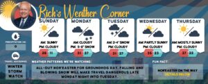
Cloudy today with milder temperatures in the mid-upper 40s. The above-normal temperatures will continue into mid-week.
Today chilly weather returns to start the weekend with dry and quiet weather tomorrow with temperatures rebounding into the 40s.
Today rain ahead of an approaching cold front. Still rather mild but falling temperatures and gusty northwest winds in the afternoon as the front moves through. A brief cool down to more seasonable levels tonight into tomorrow, with chilly weather.
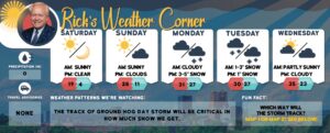
Yesterday and today felt more like spring than winter. The high of 60 yesterday broke the record of 57 set in 2006 and a high today of 60 will tie the record of 60 set in 2006. A strong cold front crosses New Hampshire tomorrow bringing an end to the record warmth. Highs tomorrow in the 50s will be early in the day followed by falling temperatures.
Temperatures will remain above average today through the end of the week before peaking tomorrow with record warmth.
Here is the forecast for Valentine’s Day: Partly to mostly sunny with a chilly wind making the high of 45 degrees feel like 39.
Today an area of low pressure will track south of Cape Cod producing partly to mostly cloudy skies. It will feel cooler than yesterday but still slightly above normal with highs in the lower 40s.
Temperatures moderate today and tomorrow with low pressure passing south of New Hampshire. Temperatures on both days are in the 40s with some clouds & sun.
Today will be 20 degrees colder than yesterday with highs in the upper 30s but feeling like 32 with a cold wind. Sunday will be milder with highs in the upper 40s.
Today will be unseasonably mild & windy with a near-record warm high of 54. High pressure builds in this weekend with quiet weather and continued above normal temperatures.
Today low-pressure tracks northwest of New Hampshire brings some showers by evening into tonight. Unseasonably mild temperatures follow tomorrow, and record highs may be challenged. Cooler weather returns this weekend, but temperatures will still be a bit above normal for this time of year.
Today becoming mostly sunny with temperatures 10 degrees warmer than yesterday. The breeze will make it feel like it’s in the mid-30s.

Today morning sunshine is followed by afternoon clouds with some light snowfall (.5-1″) tonight.
An ocean storm tracks well south and east of New England today. Otherwise, drier and mild conditions today with above normal temperatures continuing for most of the upcoming work week.

A rapid warmup will commence today ending the bitter cold and bringing temperatures back into the mid-40s. 30 degrees warmer than yesterday.

Wind chills will be below zero through noon, then as winds ease, we should see wind chills closer to 0 to 10 above. After an absolutely frigid start to the day, high temperatures rebound back into the mid-teens.
The coldest airmass of the season today into tomorrow with dangerously cold windchills at least through tomorrow morning. Temperatures quickly moderate Sunday with above-normal temperatures favored into the middle of next week.

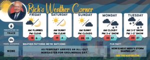
For Groundhog Day high pressure provides quiet weather with highs in the mid-30s. An arctic cold front will slam into the Granite State and send temperatures into a nosedive tomorrow. Winds gusting around 30 mph will lead to dangerously cold wind chills that can cause frostbite in just 5 to 10 minutes tomorrow afternoon into Saturday afternoon.