Rick Gordon’s Weather Watch
Follow our YouTube channel here.
Today’s Weather
Brace yourself for a brisk day ahead! Expect a chilly mix of sunshine and clouds as temperatures struggle to reach a high of 33°, but with the wind chill, it will feel more like a biting 19°. Winds will be strong, blowing from the west at 15 to over 25 mph, so make sure to bundle up if you head outside!
Polar Vortex brings the bitterness, but should ease up for Christmas week
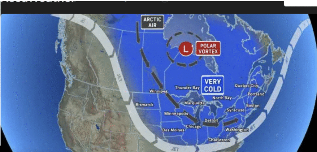
A polar vortex shift is set to bring a wave of bitter cold sweeping across the US through mid-December. Another wave of Arctic air is set to push from the northern Plains into New England today, with two or three more blasts of bitter cold likely from the Midwest to much of the East between December 10 and 19. Many Arctic air waves will bring steady snow, flurries, snow showers, and heavier snow squalls, causing slippery roads and travel disruptions.
It might be less cold during the fourth week of the month, with the chill easing up by Christmas week. Cold eases!
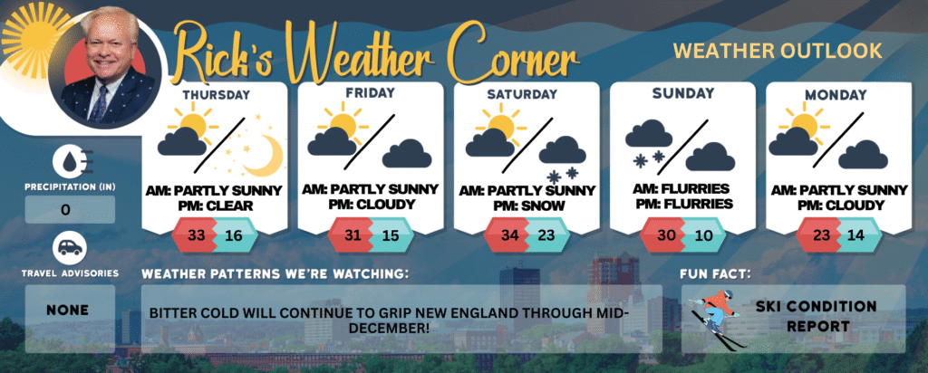
Today: Cold & windy with some sun & clouds. High 33 (feel like 19) Winds: W 15-25+ mph
Tonight: Mainly clear, breezy, & colder. Low 16 (feel like -1) Winds: W 10-20 mph
Friday: Mostly sunny, windy, and very cold. High 31 (feel like 18) Winds: W15-20 mph
Friday night: Partly cloudy & cold. Low 15 Winds: W 5-10 mph
Saturday: Cold with some sun & clouds. High 34 Winds: Light & Variable
Saturday night: Cloudy with some snow showers late. Low 23 Winds: Light & Variable
Sunday: Cloudy and cold with a snow shower early. High 30 (feel like 23) Winds: NW 10-15 mph
Sunday night: Partly cloudy and colder. Low 10 (feel like -2) Winds: NW 10-15 mph
Monday: Mainly sunny, breezy, and very cold. High 23 (feel like 10) Winds: NW 10-15 mph Monday night: Partly cloudy and cold. Low 14 (feel like 8) Winds: WNW 5-15 mph
Weather Patterns We’re Watching
Bitter cold will continue to grip New England through mid-December!
Get Out!
Elevations for summits above 4,000 feet in Northern New Hampshire today: Cloudy skies with scattered snow showers in the morning, turning to likely snow by afternoon. Highs range from 12 to 22 degrees. West winds at 20 to 30 mph, with higher elevations above 5,000 feet seeing winds around 40 mph, increasing to about 50 mph later. Snow chance is 70 percent, with wind chills dropping as low as 36 below.
Elevations between 2,500 and 4,000 feet in Northern New Hampshire today: Cloudy skies with a good chance of snow. Temperatures will reach the lower 20s, with west winds blowing at 15 to 25 mph and gusts up to 55 mph. There’s a 70 percent chance of snow, and wind chill could make it feel as cold as 20 below.