Rick Gordon’s Weather Watch
Follow our YouTube channel here.
Today’s Weather
Cloudy and windy, with an afternoon snow squall bringing a dusting of up to an inch. Highs around 38 degrees, feeling like 24, with west winds at 10 to 20 mph.
Recap of Snow Totals from Tuesday’s Storm
Manchester saw a record snowfall on Tuesday, with 9 inches, surpassing the previous record of 3.2 inches set in 1989.
Belknap County
- Laconia 10″
- Belmont 9.5″
- Meredith 9.5″
- New Hampton 9.0″
- Gilford 6″
Carroll County
- Freedom 12.6″
- Bridgewater 11″
- East Sandwich 9″
- Moultonborough 8.8″
- Albany 8.5″
- Wolfeboro 8″
- North Conway 7.4″
Cheshire County
- Rindge 7.2″
- Keene 7″
- Hinsdale 6.6″
- Roxbury 6.5″
- Westmoreland 6″
- Roxbury 6″
- Spofford 5.8″
Grafton County
- Littleton 7.8″
- Bristol 7.3″
- Ashland 6″
- Thornton 6″
- Sugar Hill 5″
- Lyme 5″
- Hanover 4.8″
Hillsborough County
- Peterborough 9.5″
- Manchester 9″
- Brookline 8″
- Hillsborough 7″
- Milford 7.3″”
- New Ipswich 8″
- Temple 6″
- Brookline 8″
- Bennington 7.6″
- Weare 5″
- Nashua 6.6″
- Hooksett 8″
- Hollis 6.4″
- Hudson 5.6″
Merrimack County
- Dunbarton 9″
- Contoocook 8.5″
- Bow 8″
- Henniker 7.5″
- South Hooksett 7″
- Concord 7″
Rockingham County
- Sandown 9.3″
- Hampstead 9.2″
- Nottingham 8.5″
- Chester 8″
- Derry 8″
- Stratham 7.4″
- Epping 7″
- Northwood 6.5″
- Deerfield 6″
- Portsmouth Airport 4.6″
- Rye 3.8″
Strafford County
- Middleton 8″
- Rochester 8″
- Dover 7″
- Rochester 7″
- Northwood 6.3″
- Barrington 6″
- New Durham 6″
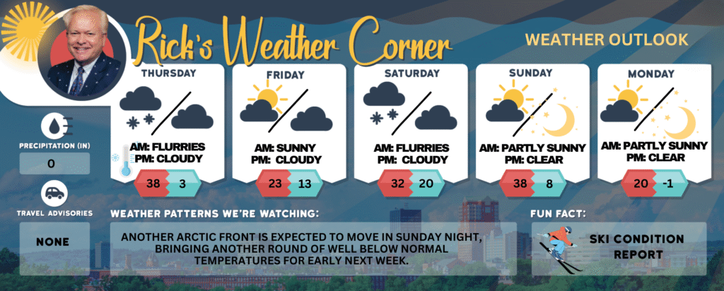
Today: Cloudy & windy with an afternoon snow squall with a dusting to an inch. High 38 (feel like 24) Winds: W 10-20 mph
Tonight: Clear, breezy, and frigid with a record tying low of 3 set in 1886. Low 3 (feel like -7) Winds: NW 10-20 mph
Friday: Mostly sunny & very cold. High 23 Winds: SW 5-10 mph
Friday night: Partly to mostly cloudy & cold. Low 13 Winds: Light & Variable
Saturday: Mostly cloudy and not as cold with some morning snow showers. High 32 Winds: Light & Variable
Saturday night: Partly cloudy & cold. Low 20 Winds: Light & Variable
Sunday: Some sun & clouds. High 38 (feel like 32) Winds: NW 5-15 mph
Sunday night: Mainly clear & frigid. Low 8 (feel like 2) Winds: NW 5-15 mph
Monday: Mostly sunny & very cold. High Around 20 (feel like 11) Winds: NW 10-15 mph
Monday night: Mainly clear & frigid. Low Around -1 Winds: Light & Variable
Weather Patterns We’re Watching
Another Arctic front is expected to move in Sunday night, bringing another round of well below normal temperatures for early next week.
Get Out!
Elevations for summits above 4,000 feet in Northern New Hampshire today: Summits will be hidden with snow showers throughout the day. Temperatures will range from 13 to 23 degrees, with west winds near 35 mph shifting northwest and increasing to about 45 mph in the afternoon. Above 5,000 feet, winds will start around 50 mph from the west, turning northwest and strengthening to about 65 mph later, with gusts reaching up to 95 mph. There’s a 90% chance of snow, and wind chills could drop as low as 45 below.
Elevations between 2,500 and 4,000 feet in Northern New Hampshire today: Summits will be hidden with a chance of snow showers. Temperatures will peak in the lower 20s, with west winds around 25 mph shifting northwest and increasing to about 35 mph in the afternoon. Gusts could reach up to 70 mph, and there’s a 50 percent chance of snow. Wind chills may drop as low as 28 below.