
Rick Gordon’s Weather Watch
Follow our YouTube channel here.
Today’s Weather
Hazy sunshine casting a warm glow on a breezy day that’s both hot and steamy. With temperatures soaring to 93 degrees, it feels even warmer at 96! The southwest winds are picking up speed, blowing in at 10 to 15 mph. Stay cool and enjoy the summer vibes!
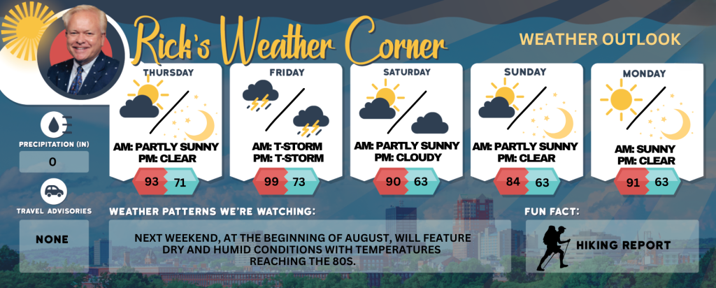
5-Day Outlook
Today: Hazy sun, breezy, hot, and more humid. High 93 (feel like 96) Winds: SW 10-15+ mph
Tonight: Clear, warm, and humid. Low 71 (feel like 73) Winds: SSW 5-10 mph
Friday: Hazy, very hot with record heat, breezy, and humid with strong afternoon thunderstorms. High 99 (record 93 set in 2016) (feel like 103) Winds: WSW 15-20+ mph
Friday night: Humid and warm with scattered thunderstorms expected early, followed by clearing later. Low 73 (feel like 75) Winds: NW 5-10 mph
Saturday: Some sun & clouds, turning less humid. High 90 Winds: NE 5-10 mph
Saturday night: Partly cloudy. Low 63 Winds: SSE 5-10 mph
Sunday: Mix of sun & clouds with slightly more humidity. High 84 Winds: S 5-10 mph
Sunday night: Mainly clear & humid. Low 63 (feel like 65) Winds: S 5-10 mph
Monday: Mainly sunny, hot, and humid. High 91 (fell like 97) Winds: W 5-15 mph
Monday night: Mainly clear & humid. Low 69 (feel like 71) Winds: S 5-10 mph
Heat & Humitidy Expand Northeastward Thurs.- Friday
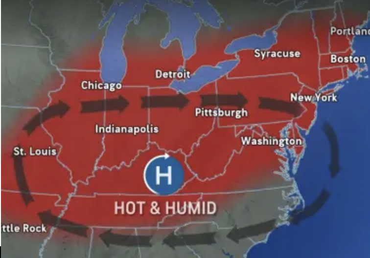
The heat is expected to rise again in New Hampshire, following the current decrease in humidity. After experiencing a welcomed stretch of lower humidity and cooler temperatures, a surge of intense heat is set to push in from a powerful heat dome hovering over the central United States today and Friday with record heat. Fortunately, a cold front is on track to sweep through, effectively reducing the heat in New England and parts of the mid-Atlantic by Sunday.
Weather Patterns We’re Watching
Next weekend, at the beginning of August, will feature dry and humid conditions with temperatures reaching the 80s.
Get Out!
Take a Hike: Summits above 4,000 feet: Mostly cloudy during the morning, followed by clearing skies. High temperatures reaching the lower 70s. West winds from 20 to 30 mph, with gusts of up 50 mph Elevations between 2,500 and 4,000 feet: Mostly cloudy conditions in the morning will transition partly sunny skies later in the day. Temperatures will reach highs in the upper 70s. West winds will range from 10 to 20 mph, with gusts potentially reaching up to 35 mph.
Hit the Beach Hampton & Rye Beach
Weather: Sunny.
UV Index: Very high.
Thunderstorm Potential: None.
High Temperature: In the lower 80s.
Winds: Southwest winds 10 to 15 mph.
Surf Height: Around 2 feet.
Water Temperature: 62 degrees.
Rip Tide Current Risk: Low.
Tides Hampton Beach: Low 0.5 feet (MLLW) 04:55 PM.
Jump in a Lake Weirs Beach:
Southwest winds at 10 to 15 mph. Waves 2, increasing to 2 to 4 feet in the afternoon. Sunny with temperatures reaching the mid-80s. Water temperature is 73 degrees.