
Rick Gordon’s Weather Watch
Follow our YouTube channel here.
Today’s Weather
Enjoy a delightful day with patches of sunshine and pleasant temperatures reaching a high of 74°! A gentle breeze from the east-northeast at 10-15 mph will keep things feeling comfortable. Perfect weather for outdoor activities!
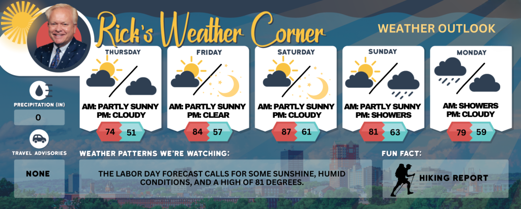
Today: Partial sunshine & nice. High 74 Winds: ENE 10-15 mph
Tonight: Partly cloudy & cool. Low 51 Winds: NNE 5-10 mph
Friday: Seasonably warm with some clouds & sun. High 84 Winds: NNE 10-15+ mph
Friday Night: Mainly Clear. Low 57 Winds Light & Variable
Saturday: Comfortable sunshine & very warm. High 87 Winds: SW 5-15 mph
Saturday night: Mainly clear. Low 61 Winds: S 5-10 mph
Sunday: Some sun early, becoming cloudy later in the day with slightly more humidity. High 81 Winds: SSW 10-15 mph
Sunday night: Cloudy & humid with some showers late. Low 63 Winds: S 5-10 mph
Monday: Humid with some showers and thunderstorms. High 79 (feel like 82) Winds: SSW 5-10 mph
Monday night: Partly cloudy and turning less humid. Low 59 Winds: SW 5-10 mph
Hurricane Erin Update
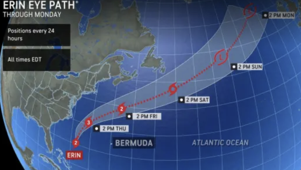
Because the hurricane may continue to grow in size, wind gusts near tropical storm force are possible in southeastern Massachusetts and the islands Thursday and Thursday night. The greatest impacts to southeastern New England will be from rough seas and dangerous surf, although some sporadic power outages are possible.
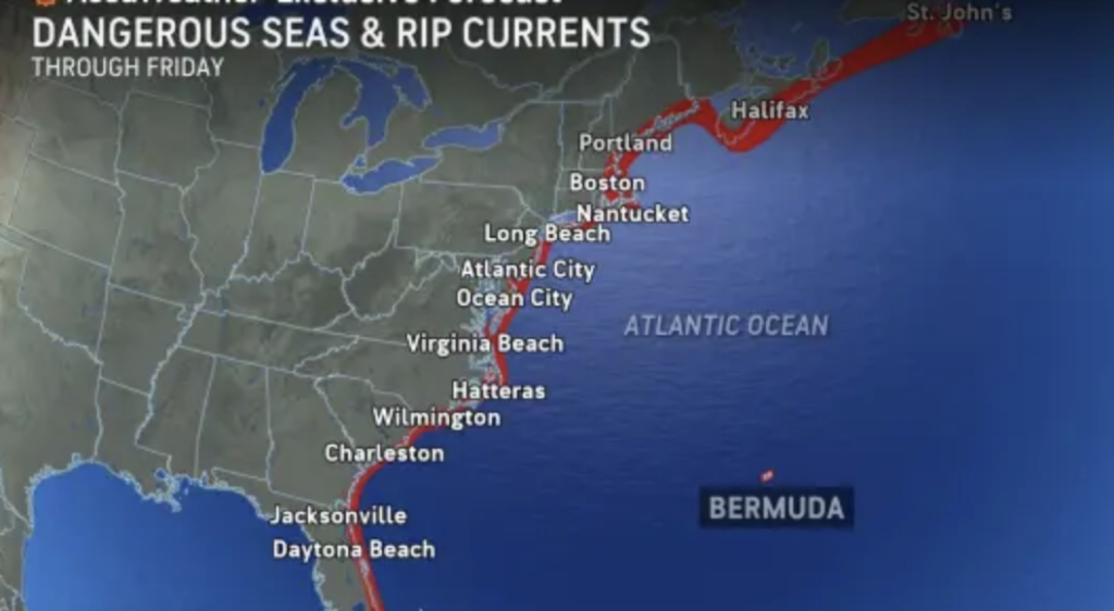
Rough seas and rip currents are expected along the New Hampshire seacoast. High rip current risk in effect from Thursday morning through Thursday evening. High surf advisory in effect from 6 a.m. Friday to 8 p.m. Saturday. A High Rip Current Risk indicates a significant danger of hazardous rip currents, while the High Surf Advisory warns of large breaking waves between 6 and 10 feet and a high risk of dangerous rip currents. These conditions are expected in Coastal Rockingham County, New Hampshire. The High Rip Current Risk is in effect from Thursday morning through Thursday evening, and the High Surf Advisory lasts from 6 AM Friday to 8 PM Saturday. Impacts include dangerous swimming and surfing conditions, localized beach erosion, and the potential for rip currents to pull even strong swimmers away from shore into deeper water. PRECAUTIONARY/PREPAREDNESS ACTIONS: Inexperienced swimmers should remain out of the water due to dangerous surf conditions.
Weather Patterns We’re Watching
The Labor Day forecast calls for some sunshine, humid conditions, and a high of 81 degrees.
Get Out!
Take a Hike: Summits above 4,000 feet: Mostly cloudy skies in the morning will give way to clearing later. Temperatures will reach the lower 60s, except for mid 50s at elevations above 5000 feet. East winds will blow up to 10 mph, with occasional gusts up to 20 mph. Elevations between 2,500 and 4,000 feet: The morning will be mostly cloudy, gradually turning partly sunny later on. Temperatures will reach the upper 60s, with light and variable winds shifting to the east at about 10 mph in the afternoon.
Hit the Beach Hampton & Rye Beach Weather: Partial sunshine. UV Index: High. Thunderstorm Potential: None. High Temperature: In the upper 60s. Winds: Northeast winds around 10 mph. Surf Height: Around 3 feet. Friday: Surf height around 6 feet. Saturday: Surf height 7 feet. Sunday: Surf heigh 5 feet. Water Temperature: 65 degrees. Rip current risk: High. Tides Hampton Beach: High 8.1 feet (MLLW) 10:37 AM. Low 0.6 feet (MLLW) 4:49 PM.
Jump in a Lake
Weirs Beach: East winds at about 5 mph, with waves around 1 foot. Morning patchy fog giving way to sunny skies. Highs in the lower 70s and water temperature at 74 degrees.