
Weather Watch with Rick Gordon
Click below for Rick’s exclusive videocast
Tuesday’s Weather
Expect a predominantly cloudy sky with high humidity and cooler temperatures; brief rain is expected in the early morning, followed by intermittent showers in the afternoon. The high will be around 80 degrees, feeling like 86.
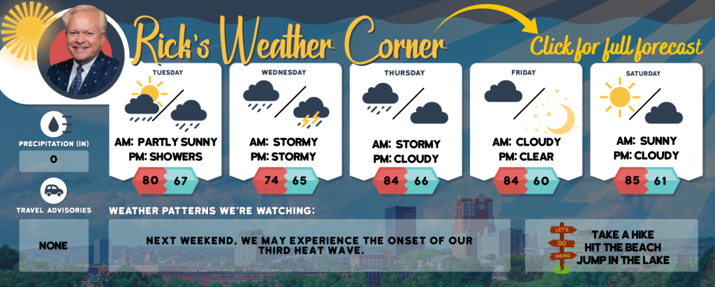
5-Day Forecast July 23-July 27
Today: Expect a mostly cloudy sky with high humidity and cooler temperatures; brief rain is likely in the early morning, followed by scattered showers in the afternoon. High 80 (feel like 86) Winds: ESE 5-10 mph
Tonight: Cloud & humid with some spot thunderstorms. Low 67 Winds: ESE 5-10 mph
Wednesday: Cloudy, not as warm temperatures, but with humidity and occasional showers and a thunderstorm, primarily later in the day. High 74 (feel like 82) Winds: ESE 5-10 mph
Wednesday night: Cloudy and humid with a thunderstorm in spots. Low 65 Winds: ESE 5-10 mph
Thursday: Expect a cloudy and humid day with afternoon showers and a thunderstorm. High 84 (feel like 89) Winds: SSW 5-10 mph
Thursday night: Partly to mostly cloudy and humid. Low 66 Wins: W 5-10 mph
Friday: Mostly sunny, breezy, and less humid. High 84 Winds: NW 10-15mph
Friday night: Mainly clear. Low 60 Winds: NW 5-10 mph
Saturday: Mostly sunny & nice. High 85 Winds: Light & Variable
Saturday night: Partly cloudy. Low 61 Winds: Light & Variable
Weather Patterns We’re Watching
This Sunday could mark the beginning of our third heat wave.
Hiking/Beach/Lake Forecasts
Take a Hike
Elevations for summits above 4,000 feet in Northern New Hampshire Today: Summits will be obscured. Expect showers and scattered thunderstorms. Temperatures will reach highs in the lower 60s. South winds will blow at speeds up to 10 mph, with gusts reaching up to 25 mph. The chance of rain is 90 percent.
Elevations between 2,500 and 4,000 feet in Northern New Hampshire Today: Expect cloudy skies with showers and scattered thunderstorms. The highs will be in the upper 60s. Winds will be light and variable, shifting to the south at around 10 mph in the afternoon. There’s a 90 percent chance of rain.
Hit the Beach
- Weather: Mostly cloudy. Patchy fog. Showers are likely with isolated thunderstorms.
- UV Index: Moderate
- Thunderstorm Potential: Moderate. Implies that thunderstorms are possible.
- High Temperature: In the lower 70s.
- Winds: Southeast winds around 5 mph.
- Water Temperature: 61 degrees.
- Surf Height: Around 2 feet.
- Tides Hampton Beach: Low -0.9 feet (MLLW) 07:40 AM EDT. High 8.8 feet (MLLW) 01:38 PM.
Jump in a Lake
Expect southeast winds at approximately 5 mph, with wave heights under one foot. The morning may bring patchy fog, followed by mostly cloudy skies and scattered thunderstorms. Showers are likely, primarily in the morning. It will be humid, with temperatures reaching the mid-70s. There’s an 80 percent chance of rain. The moderate lightning threat indicates possible thunderstorms. The water temperature will be around 76 degrees.