
Rick Gordon’s Weather Watch
Follow our YouTube channel here.
Today’s Weather
The weather will be predominantly sunny, extremely hot, and muggy, with a chance of a stray shower or thunderstorm. Temperatures are expected to exceed the record high of 95 degrees set in 2013, reaching a high of 102 degrees, but feeling more like 107 due to humidity. It is advisable to take precautions if you plan on being outdoors for extended periods. Winds will be coming from the WNW at 5-15 mph.
Weather Alert
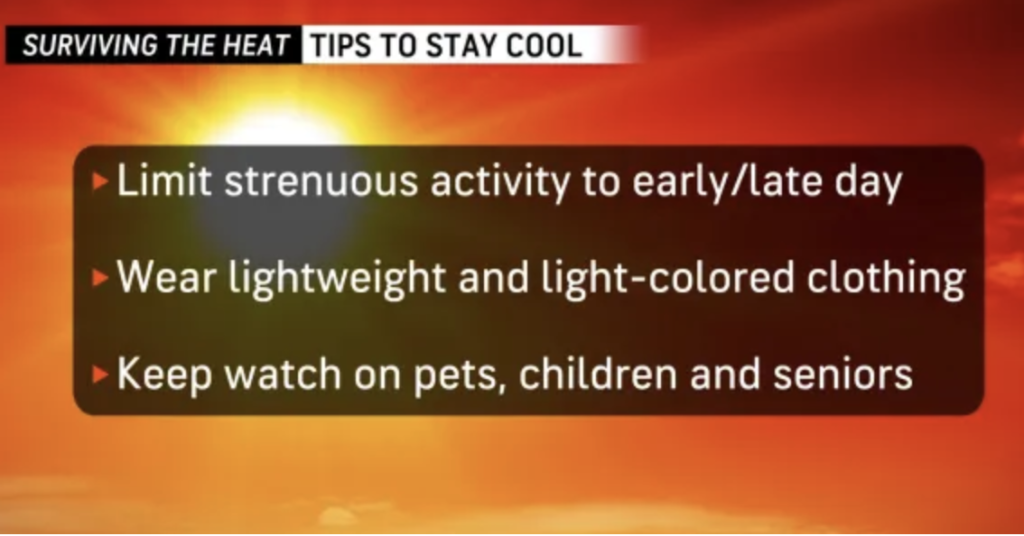
Our intense heat wave continues making today an official heat wave with 3 days of 90 degrees or higher, marking the highest temperatures since last summer and potentially in several years, both duration and humidity levels. Today an extreme heat warming until 8PM tonight with heat index values up to 107 expected. The high today 102 will break the record of 95 degrees set in 2013. Consume an ample amount of fluids, in an air-conditioned environment, avoid direct sunlight, and monitor the well-being of relatives, neighbors, and pets. Never leave young children or pets unattended in vehicles, as car interiors can reach fatal temperatures within minutes. Prioritize staying cool, hydrated, and informed.
5-Day Outlook
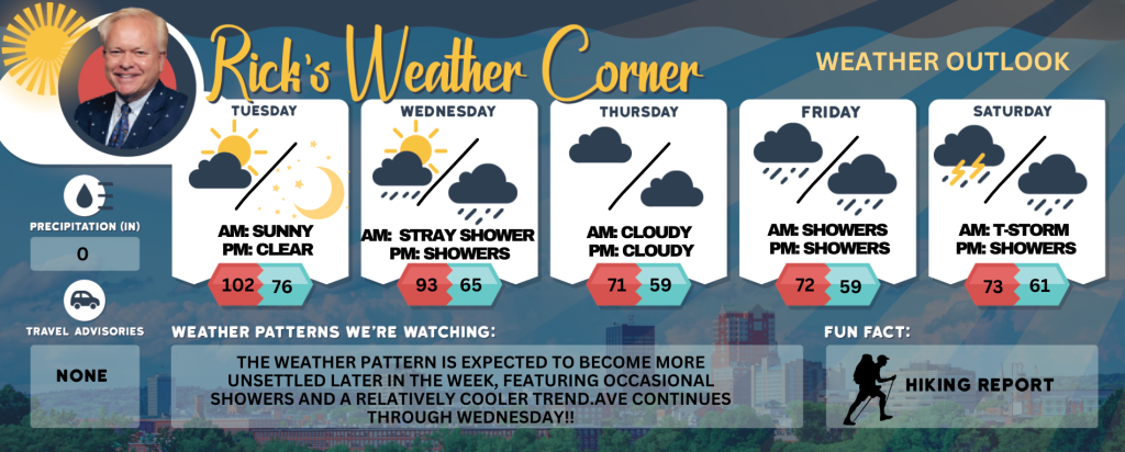
Today: Predominantly sunny extremely hot and muggy with temperatures surpassing the record of 95 degrees set in 2013; precautions are recommended for prolonged outdoor activities. High 102 (feel like 107) Winds: WNW 5-15 mph
Tonight: Partly cloudy, muggy, and very warm. Low 76 (feel like 79) Winds: NW 5-10 mph
Wednesday: The las day of our 4-day heat wave. Some sun, hot, and humid with a stray shower or thunderstorm. High 93 (feel like 99) Winds: NNW 5-10 mph
Wednesday night: Few showers late and turning less humid. Low 65 Winds: NNE 5-10 mph Thursday: Cloudy and comfortable. High 71 Winds: Light & Variable
Thursday night: Partly cloudy. Low 59 Wings: Light & Variable Friday: Cloudy & cool with a slight chance of an afternoon shower. High 72 Winds: ESE 5-10 mph
Friday night: Mostly cloudy with some showers late. Low 59 Winds: SE 5-10 mph
Saturday: Cloudy & cool with some afternoon thunderstorms. High 73 Winds: SE 5-10 mph
Saturday night: Cloudy with evening showers. Low 61 Wins: ESE 5-10 mph
Weather Patterns We’re Watching
The weather pattern is expected to become more unsettled later in the week, featuring occasional showers and a relatively cooler trend.
Get Out!
Take a Hike: Summits above 4,000 feet: Partly sunny in the morning, then becoming mostly cloudy. Highs in the upper 70s… except in the lower 70s at elevations above 5000 feet. West winds 20 to 30 mph with gusts up to 55 mph. Elevations between 2,500 and 4,000 feet: Partly sunny in the morning, then becoming mostly cloudy. Highs in the lower 80s. West winds 15 to 25 mph with gusts up to 50 mph.
Hit the Beach Hampton & Rye Beach Weather: Mostly sunny. UV Index: Very high. Thunderstorm Potential: None. High Temperature: In the lower 90s. Winds: West winds around 5 mph. Surf Height: Around 2 feet. Water Temperature: 60 degrees. Rip Tide Current Risk: Low. Tides Hampton Beach: High 8.5 feet (MLLW) 10:56 Am. Low 0.2 feet (MLLW) 05:05 PM.
Jump in a Lake Weirs Beach: West winds at approximately mph, with gusts reaching up to 20 mph. Waves measuring around 2 feet. Conditions are sunny and hot, with temperatures peaking in lower 90s. The water temperature is recorded at 66 degrees.