
Rick Gordon’s Weather Watch
Follow our YouTube channel here.
Today’s Weather
Today (July 1): Expect a cloudy day with high humidity, making it feel even warmer, around 95 degrees. Thunderstorms may be on the horizon, so be prepared for sudden changes in the weather. Some thunderstorms may be severe with gusty winds and heavy rainfall in the afternoon. The high will reach 88 degrees, with winds coming from the SSW at 5-15 mph. Stay cool and stay safe!
Weather Alerts
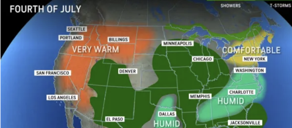
As the July 4th weekend approaches, conditions across much of New England are expected to be highly favorable, assuming high pressure gradually settles over the region instead of shifting off the Atlantic coast. Humidity levels are anticipated to be lower than typical July standards through Saturday, which is excellent news for enjoying fireworks displays.
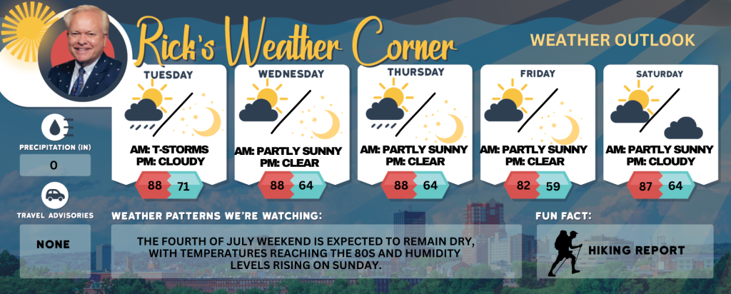
5-Day Outlook
Today (July 1): Cloudy, very warm, & muggy with thunderstorms possible. Some thunderstorms may be severe with gusty winds and heavy rainfall in the afternoon. High 88 (feel like 95) Winds: SSW 10-15+ mph
Tonight: Partly cloudy, warm, & humid. Low 71 (feel like 72) Winds: WSW 5-10 mph
Wednesday: Some sun, breezy, and less humid. High 88 Winds: W 5-15 mph
Wednesday night: Clear. Low 64 Winds: W 5-10 mph
Thursday: Some sun, breezy, and very warm, a thunderstorm in spots in the afternoon. High 88 Winds: W 10-15+ mph
Thursday night: Clear to partly cloudy. Low 64 Winds: WNW 5-10 mph
Friday (4th of July): Mostly sunny and nice. High 82 Winds: NW 10-15 mph
Friday night: Great viewing for fireworks. Mainly clear & cool. Low 59 Winds: NW 5-10 mph
Saturday: Comfortable with some sun & clouds. High 87 Winds: W 5-10 mph
Saturday night: Partly cloudy. Low 64 Winds: Light & Variable
Weather Patterns We’re Watching
The Fourth of July weekend is expected to remain dry, with temperatures reaching the 80s and humidity levels rising on Sunday.
Get Out!
Take a Hike: Summits above 4,000 feet: Summits obscured. Showers and scattered thunderstorms. Some thunderstorms may produce gusty winds and heavy rainfall in the morning. Some thunderstorms may be severe with gusty winds and heavy rainfall in the afternoon. Highs in the upper 60s… except in the lower 60s at elevations above 5000 feet. Southwest winds 15 to 25 mph with gusts up to 45 mph. Chance of rain 80 percent. Elevations between 2,500 and 4,000 feet: Summits obscured. Showers likely with scattered thunderstorms. Some thunderstorms may produce gusty winds and heavy rainfall in the morning. Some thunderstorms may be severe with gusty winds and heavy rainfall in the afternoon. Highs in the lower 70s. Southwest winds 10 to 15 mph with gusts up to 35 mph. Chance of rain 70 percent.
Hit the Beach Hampton & Rye Beach
Weather: Partly sunny skies with areas of patchy fog. Showers are likely, accompanied by isolated thunderstorms.
Thunderstorm Potential: Low.
UV Index: Moderate.
Thunderstorm Potential: Low.
High Temperature: In the lower 80s.
Winds: South winds around 10 mph.
Surf Height: Around 3 feet.
Water Temperature: 60 degrees.
Rip Tide Current Risk: Low.
Tides Hampton Beach: Low 0.4 feet (MLLW) 11:00 AM. High 8.2 feet (MLLW) 05:03 PM.
Jump in a Lake Weirs Beach: Southwest winds of 5 to 10 mph, with waves approximately 2 feet. Morning fog is expected in certain areas. Showers are likely, with isolated thunderstorms in the morning transitioning to scattered thunderstorms in the afternoon Some thunderstorms may bring gusty winds and heavy rainfall in the morning, while others could be severe with gusty winds and heavy rainfall in the afternoon. The day will be humid, with high temperatures around 80 degrees. The chance of rain is 70 percent, and the water temperature is 69 degrees.