Rick Gordon’s Weather Watch
Follow our YouTube channel here.
Weather Watch
Start your day with a sprinkle of morning snow showers, setting the stage for a cozy atmosphere! As more clouds than sun take over, expect a mild high of 41 degrees. A gentle breeze from the south at 5-10 mph will keep things feeling just right. Embrace the wintery vibes!
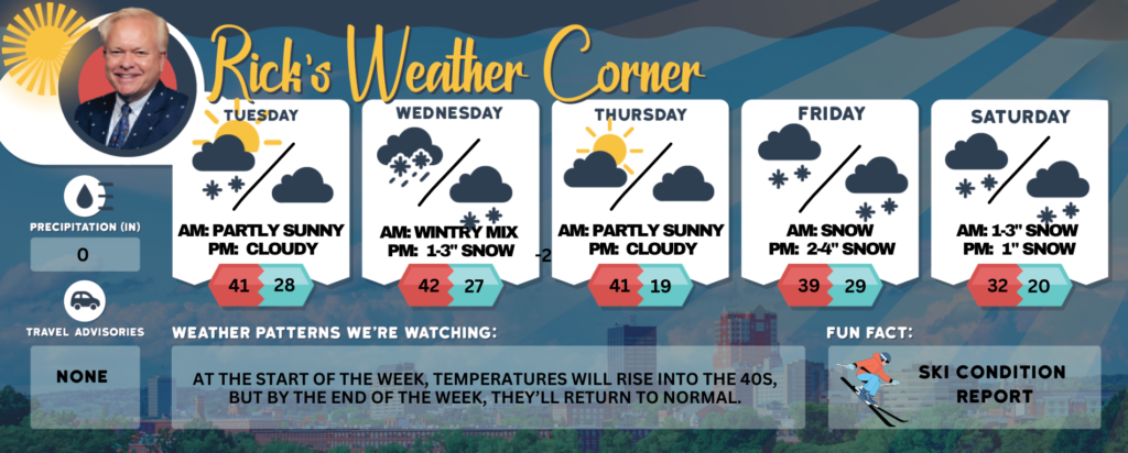
Today: A couple of morning snow showers; otherwise, more clouds than sun & mild. High 41 Winds: S 5-10 mph
Tonight: Partly to mostly cloudy. Low 28 Winds: Light & Variable
Wednesday: Mainly cloudy with some rain or snow showers in the afternoon. High 42 Winds: Light & Variable
Wednesday night: Cloudy skies with a mix of snow and rain, gradually ending as snow with 1-3 inches of accumulation; be cautious of slippery areas. Low 27 Winds: Light & Variable
Thursday: Sunshine and some clouds. High 41 Winds light and variable.
Thursday night: Partly cloudy & cold. Low 19 Winds: Light & Variable
Friday: Cloudy with snow developing later in the day. High 39 Winds NE at 5 to 10 mph
Friday night: Some snow (2-4″). Low 29 Winds: NE 5-10 mph
Saturday: Periods of snow (1-3″). High 32 (feel like 25) Winds: NNE 5-15 mph
Saturday night: Some clouds with snow showers (1″) Low 20 (feel like 18) Winds: Light & Variable
Weather Patterns We’re Watching
At the start of the week, temperatures will rise into the 40s, but by the end of the week, they’ll return to normal.
Get Out!
Elevations for summits above 4,000 feet in Northern New Hampshire today: Summits will be hidden, with snow likely in the morning and a chance of more in the afternoon. Highs will reach the upper 20s, with west winds blowing at 15 to 25 mph and gusts up to 45 mph. There’s a 60 percent chance of snow.
Elevations between 2,500 and 4,000 feet in Northern New Hampshire today: Summits will be hidden with a chance of snow. Temperatures will reach the lower 30s, with west winds blowing at 10 to 15 mph and gusts up to 35 mph. There’s a 50 percent chance of snowfall.