Rick Gordon’s Weather Watch
Follow our YouTube channel here.
Today’s Weather
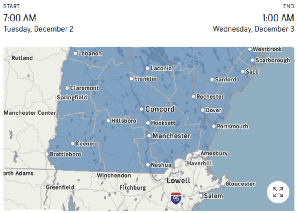
**WINTER STORM WARNING IN EFFECT FROM 8 AM TODAY UNTIL 4 AM WEDNESDAY. **

A snowstorm is expected to bring heavy snowfall. Moderate snow and low visibility will be the primary hazards. There is a possibility of snow bands that may produce periods of heavy snowfall, with accumulations of up to an inch per hour. This may lead to rapid snow accumulation and extremely dangerous travel conditions. The combination of moderate to heavy snow and low visibility will result in hazardous driving conditions. These dangerous conditions may affect both morning and evening commutes.
Meteorological Winter is Here!
Get ready for a frosty start to December with several exciting chances of snow on the horizon! Bundle up and embrace the chill as winter casts its spell! The cold temperatures settling in during the first two weeks will bring the lowest readings since last February. We are expecting our first major snow today, with heavy snow in southern New Hampshire. Currently, 7 to 12 inches of snow is likely; More snow is also expected this weekend. Additionally, at least two more storms are possible during the first half of December, in conjunction with today’s snow and the weekend’s snowfall.
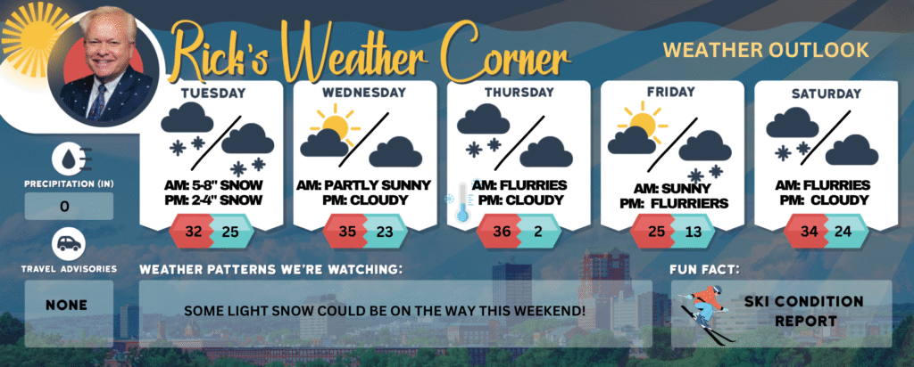
Today: Cold with snow (5-8″). High 32 Winds: NNE 5-15 mph
Tonight: Early snow (2-4″) with some clearing late. Low 25 (feel like 15) Winds: NNW 10-15 mph
Wednesday: Sunshine with some clouds & cold. High 35 Winds: WNW 5-10 mph
Wednesday night: Partly cloudy & cold. Low 23 Winds: Light & Variable
Thursday: Clouds with some afternoon sun along with a few flurries. High 36 (feel like 28) Winds: W 10-15 mph
Thursday night: Partly cloudy, breezy, and frigid. Low 4 (feel like -1) Winds: NW 10-15+ mph
Friday: Mostly sunny & very cold. High 25 Winds: Light & Variable
Friday night: Partly cloudy & cold. Low 13 Winds: Light & Variable
Saturday: Mostly cloudy and not as cold with a few snow showers late. High 34 Winds: Light & Variable
Saturday night: Partly cloudy. Low 24 Winds: Light & Variable
Weather Patterns We’re Watching
Some light snow could be on the way this weekend!
Get Out!
Elevations for summits above 4,000 feet in Northern New Hampshire today: Snowy weather (4-6″) with highs in the low 20s, south winds at 10 to 15 mph, and gusts reaching up to 35 mph. Nearly a 100 percent chance of snow.
Elevations between 2,500 and 4,000 feet in Northern New Hampshire today: Expect snow (4-6″) with highs in the lower 20s. South winds around 10 mph in the morning will become light and variable, with gusts up to 25 mph. There’s nearly a 100 percent chance of snow.