Rick Gordon’s Weather Watch
Follow our YouTube channel here.
Weather Watch
Get ready for a breezy day filled with bursts of sunshine, but don’t forget to bundle up! With a high of 30 degrees, it might feel more like 18 thanks to the northwest winds gusting at 10 to 20 mph with blowing snow. Perfect weather for a cozy sweater or a warm cup of coffee!
YES, IT WAS A BLIZZARD
Manchester did get a blizzard yesterday! What is a Blizzard? A blizzard is not defined by how much snow falls — it’s defined by wind and visibility, and how long those conditions last.
National Weather Service (NWS) Blizzard Criteria To be classified as a blizzard, all of the following must occur for at least 3 hours:
- Sustained winds or frequent gusts ≥ 35 mph
- Visibility ≤ 1/4 mile
- Falling or blowing snow that reduces visibility
- Duration: 3 hours or more
Manchester Airport observations 9-11 AM 10:53 N 23 G 40 0.25 Snow Blowing Snow Freezing Fog 09:53 N 20 G 37 0.25 Heavy Snow Freezing Fog 08:53 N 15 G 35 0.25 Snow Freezing Fog Snowfall amount is not part of the definition — you can technically have a blizzard with very little new snow if winds are strong enough to loft existing snow.
Highest Wind Gust
Hillsborough County:
- Nashua 50 MPH 10:34 AM
- Manchester 44 MPH 10:57 AM
Rockingham County:
- Portsmouth 47 MPH 11:48 AM
Strafford County:
- Rochester 44 MPH 11:31 AM
Maine Maritime Stations:
- Kittery 67 MPH 10:28 AM
- Kittery Point 60 MPH 11:01 AM
- Portland Buoy 56 MPH 11:40 AM
- Western Maine Shelf 54 MPH 10:30 AM
- Ogunquit 49 MPH 10:55 AM
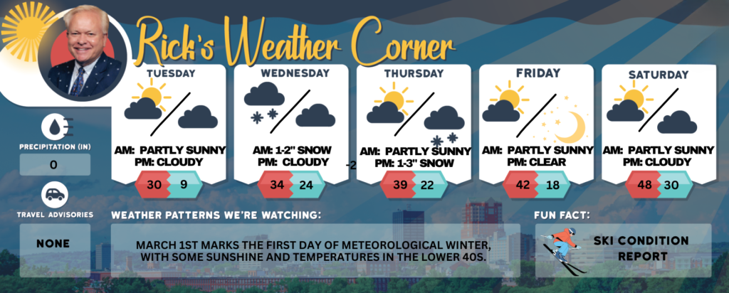
Today: Breezy with some sun and cold. High 30 (feel like 18) Winds: NW 10-20 mph
Tonight: Partly to mostly cloudy & frigid. Low 9 Winds: Light & Variable
Wednesday: Cloudy with periods of snow (1-2″) & flurries. High 34 Winds: Light & Variable
Wednesday night: Mostly cloudy. Low 24 Winds: Light & Variable
Thursday: Not as cold with a mix of clouds and sunshine. High 39 (feel like 34) Winds: W 5-15 mph
Thursday night: Cloudy with snow (1-3″). Low 22 Winds: Light & Variable
Friday: Milder with some sun & clouds. High 42 (feel like 37) Winds: NW 5-10 mph
Friday night: Mainly clear and cold. Low 18 Winds: Light & Variable
Saturday (Last day of February): Some sun & mild. High 48 (feel like 43) Winds: SSW 10-15 mph
Saturday night: Partly cloudy. Low 30 Winds: SW 5-10 mph
Weather Patterns We’re Watching
March 1st marks the first day of Meteorological Winter, with some sunshine and temperatures in the lower 40s.
Get Out!
Elevations for summits above 4,000 feet in Northern New Hampshire today: Summits are hidden in the clouds, with highs ranging from 3 to 13 degrees above. Northwest winds will blow at 20 to 30 mph, increasing to around 50 mph above 5000 feet before shifting west and easing to about 40 mph in the afternoon. Wind chills could drop as low as 36 below.
Elevations between 2,500 and 4,000 feet in Northern New Hampshire today: Mostly cloudy with temperatures ranging from 7 to 17 degrees above. Northwest winds will blow at 15 to 25 mph, with gusts reaching up to 55 mph. Wind chills could make it feel as cold as 22 below.